


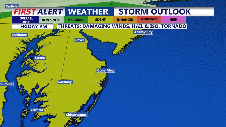


DELMARVA - Sussex County residents should brace for a turbulent stretch of weather beginning late Friday, as a strong low-pressure system moves through the region, bringing a mix of heavy rain, flood potential, and severe thunderstorms.
Rain is expected to begin overspreading Sussex County from the southwest between 7 and 8 p.m. Friday. Forecast models predict a steady downpour continuing through the overnight hours, with rainfall totals ranging from one to three inches across the region. With the ground already saturated, this raises concerns for localized flooding, particularly in urban and poorly drained areas.
The National Weather Service has issued a Flood Watch from 7 p.m. Friday through 8 a.m. Saturday for parts of northern Delaware, though Sussex County lies on the fringe of the highest rainfall swath. However, rainfall rates may exceed an inch per hour at times, according to high-resolution models, which could still create flash flooding conditions locally.
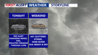
Alongside the flood threat, there’s a chance for severe thunderstorms Friday evening, particularly between 4 and 10 p.m. The Storm Prediction Center has expanded a Slight Risk for severe weather across all of Delaware, including Sussex County. While the risk is conditional, forecasters note that if instability increases, strong storms could sweep eastward from northern Virginia and intensify over the Eastern Shore. These storms may bring damaging winds and isolated hail.
Conditions may briefly calm Saturday morning as the initial storm system departs, but don’t expect a fully dry day. A second round of showers and possible thunderstorms is expected Saturday afternoon and evening, tied to an approaching cold front. The main concern in this round will again be gusty winds, with possible small hail, and renewed downpours in areas that may already be waterlogged.
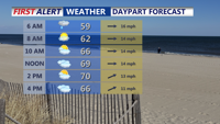
By Saturday night, conditions begin to improve. The rain tapers off as the front moves offshore, with skies clearing and temperatures dipping into the upper 40s and low 50s overnight.
Sunday brings a break from the wet weather, with breezy conditions and highs in the mid to upper 60s. Gusts up to 30 mph are expected as cooler, drier air settles in. Skies will remain mostly sunny with only a slight chance of sprinkles inland.
Looking ahead, a quiet and warming trend is expected early next week. High pressure will dominate the Mid-Atlantic through Wednesday, pushing temperatures into the upper 80s by midweek. Another cold front is expected late Thursday, possibly bringing more showers and storms before a cooler air mass arrives.