


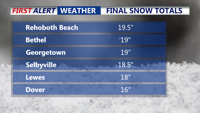
The powerful blizzard that delivered significant snowfall, with well over a foot reported, has moved out to sea. Gusty winds and coastal concerns continue.
From
To

We continue to see a prolonged stretch of dangerous, potentially record-setting cold across Delmarva that will last through the remainder of the week and into the weekend.

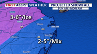
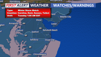
A winter storm warning remains in effect for the Delmarva Peninsula until Monday afternoon as snow spreads across Sussex County early Sunday and transitions to sleet, freezing rain and rain later in the day.

A winter storm warning remains in effect for the Delmarva Peninsula until Monday afternoon and has arrived on our doorstep at this time.

An Arctic high-pressure system will bring cold and dry conditions to Delmarva through the weekend, with wind chills dropping into the teens and lows in the 20s. Widespread significant snowfall is expected Monday impacting travel, with lingering effects throughout the week as cold high pressure dominates the region.

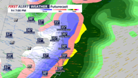
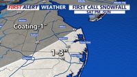
Delmarva will see its first round of winter weather Friday evening, with a weak low-pressure system bringing a coating to an inch of snowfall. A stronger storm system Sunday night into Monday could result in significant snow accumulations, followed by an arctic air mass keeping temperatures below freezing through the week.