


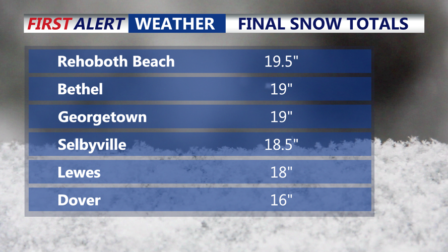
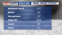


DELMARVA- The powerful blizzard that delivered significant snowfall, with well over a foot reported, has moved out to sea. Gusty winds and coastal concerns continue.
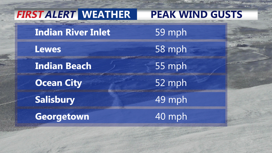
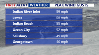
The snow totals of 10 to 20 inches from the storm have been impressive, but the wind was equally impressive. We saw gusts near 60 mph at Indian River Inlet creating near-whiteout conditions at times and contributing to widespread drifting.
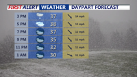
A few snow showers are still possible this afternoon, but the accumulating snow has ended. Even as winds gradually ease, northwest gusts of 30 to 40 mph will persist much of the day. That means blowing snow will remain a concern, especially near open fields and exposed roadways. Snow can be blown back onto previously cleared roads, causing sudden slick spots and brief drops in visibility that can catch drivers off guard.
The weight of the heavy, wet snow has already caused problems across the peninsula. Downed trees and powerlines have led to power outages in some areas, and conditions will remain difficult for crews as winds continue. If you’re shoveling today, use extra caution: the snow is dense and wet, increasing the risk of strain and injury. The slow improvement later today will be helped by temperatures climbing above freezing into the mid to upper 30s, but cleanup and travel will still be challenging.
Along the coast, flooding remains an ongoing concern, particularly for back-bay communities. Coastal Flood Advisories are now in effect for areas that were previously under Coastal Flood Warnings. Localized moderate coastal flooding is possible as strong northwest winds continue to push water into vulnerable back-bay locations. Additional tidal flooding may linger with the high tide tonight into early Tuesday.
Tonight, skies turn partly cloudy, but the colder air locks in. Temperatures fall into the upper teens and low 20s, meaning any slush, standing water, and partially melted snow will refreeze by Tuesday morning. Tuesday stays blustery under partly cloudy skies, with highs in the low to mid 30s.
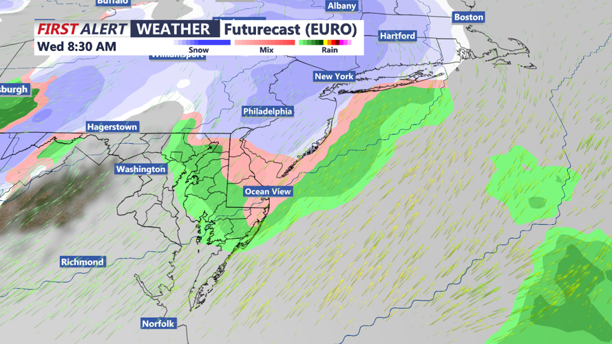
Looking ahead, high pressure moves off the Southeast Coast Tuesday, allowing the next system to approach Tuesday night. Rain may mix with snow and eventually change to snow Wednesday morning before ending. As that system pulls away, winds turn southwest and warmer air arrives, pushing highs into the 40s Wednesday under clearing skies. That should allow at least some of the snowpack to begin melting.
Another storm system could affect the region late Thursday into Friday. Precipitation may develop Thursday, with the bulk of the action Thursday night and ending Friday morning. It may start as a rain/snow mix before changing to plain rain for areas south and east of the Fall Line, while areas north and west could stay mainly snow. At this time, confidence is low on timing, track, and snowfall amounts. Temperatures should rebound into the 40s again by Friday.
Stay up to date on the approaching winter storm with radar and hourly forecasts in the CoastTV weather app, available for Apple and Android.
