


Delmarva started the day with a cold morning, with many spots away from the coast in the 20s, but sunshine and lighter winds will help temperatures recover into the mid to upper 50s and near 60 this afternoon. Milder air builds in tonight and Wednesday, with highs surging into the upper 60s and low 70s. Even warmer weather arrives Thursday and Friday before a cooler pattern and the chance for beneficial widespread rain return this weekend.
From
To

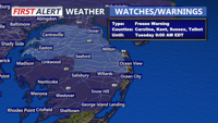
Today starts a much cooler stretch across Delmarva with mostly cloudy skies, highs in the mid 50s, and gusty winds. The biggest concern is tonight, when a widespread freeze is expected inland with a Freeze Warning in effect from midnight to 9 AM Tuesday. After a chilly Tuesday, temperatures rebound into the 60s and 70s by mid to late week before cooler weather and a better chance of rain return for the weekend.

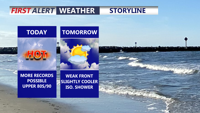
Today marks the third straight day of record-setting heat potential across Delmarva, with highs reaching the upper 80s to around 90 under partly cloudy skies. Dry air, gusty southwest winds, and ongoing drought conditions will also create an elevated fire weather risk. A weak front brings only slight cooling Friday, while a sharper cooldown arrives over the weekend with much-needed rain late Saturday night into Sunday. Early next week turns significantly cooler, with frost or even freeze conditions possible by Monday night into Tuesday morning before temperatures rebound by midweek.

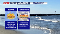
Today brings a burst of spring warmth to Delmarva with highs climbing into the mid to upper 70s inland and upper 60s at the beaches under partly cloudy skies and gusty southwest winds. A cold front moves through Friday, bringing late morning showers and scattered rain through the afternoon and evening as temperatures steadily fall. Chilly air settles in for Saturday, but a milder and more unsettled pattern returns by early next week with several rain chances and temperatures potentially nearing 80 by Wednesday and Thursday.

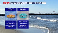
Today brings a return to seasonable temperatures across Delmarva with a mix of sun and clouds and highs in the low to mid 50s. Clouds increase tonight as high pressure slides offshore, with overnight lows holding in the mid to upper 40s. A cold front arrives late Thursday into Friday, bringing showers, gusty winds, and even a slight chance for thunder before cooler-than-normal air settles in for the weekend.

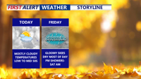
Delmarva stays cloudy but dry today with highs in the 50s; rain arrives Friday night before cooler, brighter conditions return for the weekend.

A warm and dry pattern continues for Delmarva, with high pressure maintaining clear skies and unseasonably warm temperatures through Thursday. A cold front will bring a slight chance of rain early Friday, followed by a cooler weekend before temperatures warm again next week.