


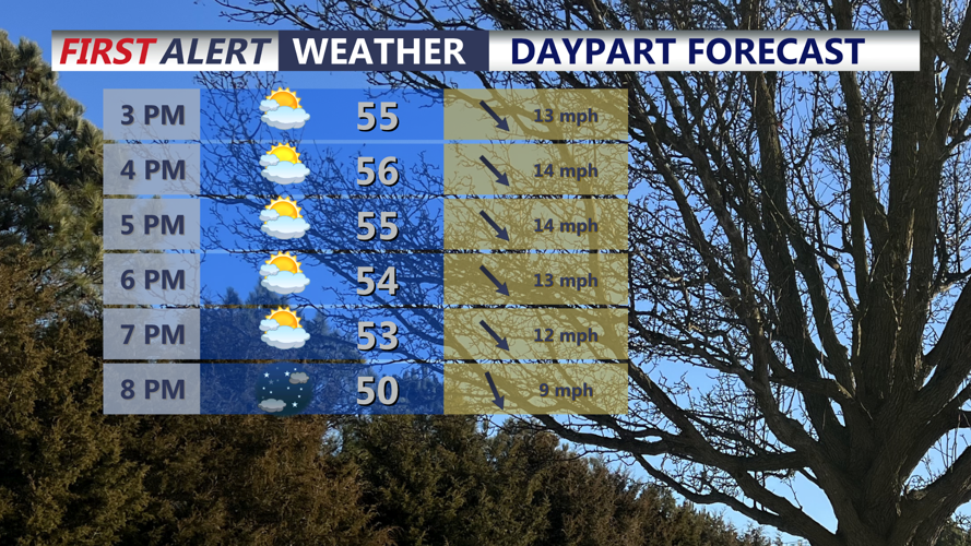


DELMARVA -- A much colder pattern is settling in after record highs last week. A cold front moving through the region is bringing temperatures back below average to start the new week. Expect mostly cloudy skies with afternoon highs in the mid to upper 50s, along with a gusty west-northwest wind that could reach up to 35 mph. An isolated shower cannot be ruled out, but most areas will stay dry.

Mostly cloudy below average afternoon, isolated shower possible, winds will gust to 30 to 35 mph.
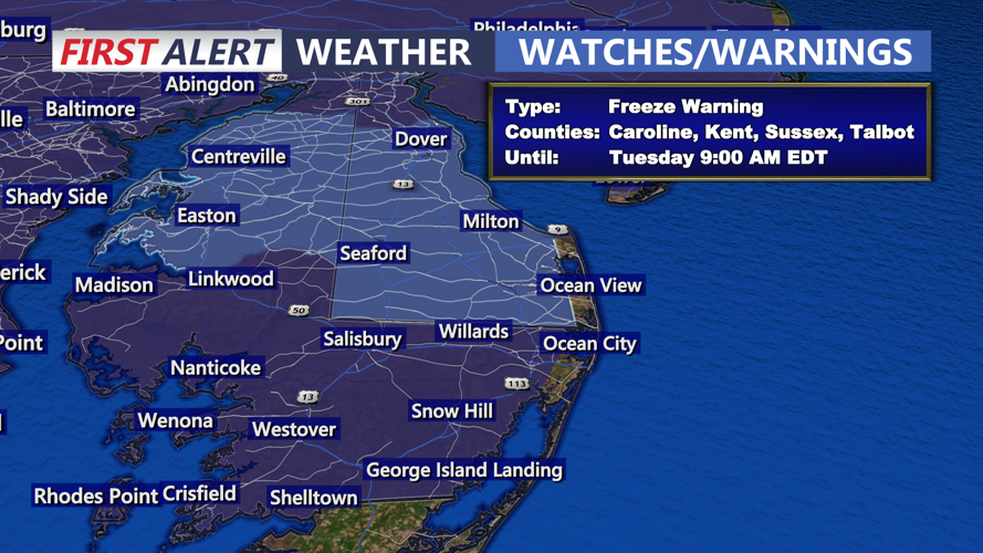
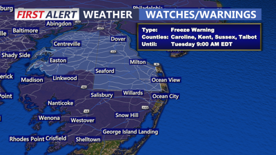
Tonight, skies will gradually clear as high pressure builds in from the Great Lakes and moves overhead. With lighter winds and better radiational cooling setting up, temperatures will fall quickly after sunset. A widespread freeze is expected late tonight into early Tuesday morning, and a Freeze Warning is in effect from midnight through 9 AM Tuesday for all areas except the immediate coast. Lows will drop into the mid 20s to low 30s inland, while coastal locations stay somewhat milder in the mid to upper 30s.

Areas away from the coast will fall into the upper 20s to low 30s under clear skies.
This freeze is especially concerning because all of Delmarva’s counties are now in the active growing season following the recent stretch of excessive warmth. Blooms and vegetation have developed quickly, and some plants are already ahead of schedule. Fruit trees and other cold-sensitive vegetation are most vulnerable. While frost formation may be a bit limited because of the drier air in place, the freezing temperatures alone could still cause damage.

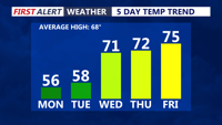
It's a quick cool down, temperatures rising back into the low to mid 70s by mid to late week.
Tuesday will stay cool, but conditions improve with mostly sunny skies and highs in the upper 50s to near 60. It will still be running about 10 to 12 degrees below average through the first half of the week. Tuesday night should not be as cold as clouds increase and a southerly flow begins to develop.
By Wednesday through Friday, a warming trend returns across Delmarva. Highs are expected to reach the low 70s on Wednesday, then climb into the mid 70s Thursday and Friday as warmer air moves in. Later in the week, a front may approach Friday into Saturday with the chance for a few showers and cooler marine air, especially near the coast.
Looking ahead to the weekend, temperatures are expected to cool back to near or below average. There is also a growing chance for more widespread showers or a period of rain, especially by Sunday, although the exact timing and strength of that system remain less certain.
