




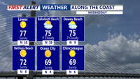
High pressure will keep Sussex County dry from early Wednesday through early Thursday, with pleasant conditions and a gradual warming trend underway.
From
To

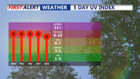
High pressure will keep Sussex County dry late tonight through Wednesday, with seasonably cool overnight temperatures and pleasant conditions continuing through midweek

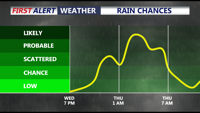
Delmarva will see mostly cloudy, mild, and breezy conditions today as a cold front approaches. A few showers are possible early this afternoon, but most of the day should stay dry. Rain chances increase late this evening through Thursday morning, with a brief downpour or isolated rumble of thunder possible. Cooler air settles in Thursday before an unsettled weekend brings additional rain chances.


Today stays warm and sunny across Delmarva, but temperatures step down from yesterday’s record highs. Cooler air arrives near the coast Saturday as a backdoor front pushes in, while inland areas stay milder. Minor tidal flooding is expected along the Delaware coast and Delaware Bay Saturday evening into Saturday night, followed by showers, a few thunderstorms, and a sharp cool down late Saturday night into Sunday. Much colder air settles in early next week, with widespread frost or freeze conditions likely Monday night into Tuesday morning.

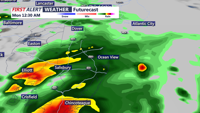
While severe storms remain west and south of the region, Delmarva starts the week under persistent cloud cover, patchy fog, and a low-end risk of isolated storms as a cold front approaches. Warmer, sunnier days are on the horizon by midweek.


Sunday afternoon across Delmarva will remain mostly dry with lingering clouds and highs in the upper 50s to low 60s. A warming trend begins Monday as a warm front lifts north, followed by a cold front Monday night that could bring showers and isolated thunderstorms. Another dry cold front passes Tuesday, ushering in cooler, breezy conditions midweek before temperatures rebound by the weekend.