


DELMARVA -- As low pressure passes over the Great Lakes, it will nudge a warm front slowly into Delmarva tonight while Hurricane Ernesto remains well off the coast. The combination of increasing moisture from the south and upper-level disturbances moving through will set the stage for showers and thunderstorms, particularly late tonight. Expect rain to develop overnight, with lows in the mid-60s to around 70. Winds will be light, primarily from the southeast.
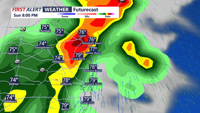
Sunday will begin with a round of heavy showers and thunderstorms early in the morning as the warm front pushes northward. There may be a brief lull in activity late morning into early afternoon, but don’t be fooled—another round of storms is likely in the afternoon as a cold front begins its approach.
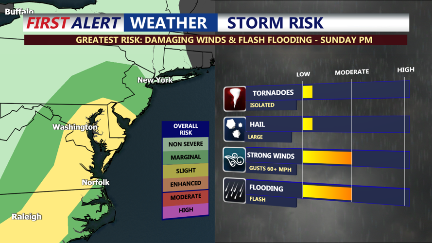
The afternoon and evening hours carry the potential for severe weather. If there are any breaks in the clouds, daytime heating could increase instability, enhancing the risk for severe storms. The Storm Prediction Center has placed Delmarva in a Slight Risk (2 out of 5) for severe weather, meaning damaging winds and isolated tornadoes cannot be ruled out. Highs on Sunday will reach the low 80s, with dew points in the low to mid-70s, contributing to the muggy conditions.

Showers and storms will continue into the evening before gradually moving offshore after midnight. Overnight lows will cool to the mid-60s to around 70. Be mindful of the potential for localized flooding and severe weather through the evening hours.
HIGH RIP CURRENT RISK CONTINUES...Keep in mind the high risk for dangerous rip currents continues through Monday, so use caution and pay close attention to the lifeguards.

The cold front from Sunday will stall near the coast, keeping the threat for showers and thunderstorms in the forecast for Monday, particularly later in the day as a secondary boundary moves through. This second front will help push the initial boundary farther offshore, bringing drier and cooler air into the region by Monday night. Highs will be in the upper 70s to low 80s, with lingering showers possible into the evening.
On Tuesday, a final boundary will move across Delmarva, bringing the chance for some light showers, mainly in the morning. The main story for Tuesday will be the noticeably cooler temperatures, with highs only reaching the mid-70s under partly to mostly cloudy skies. Breezy conditions will make it feel even cooler, offering a refreshing change from the recent humid weather.
