


For Delmarva, tonight brings a shift in weather as a cold front currently positioned across upstate New York makes its way into our region. The front is expected to move in around midnight and will continue to push southwestward through Thursday morning, likely clearing the area by late morning. As high pressure builds over northern New England, this front will act more like a back-door cold front, ushering in cooler, maritime air that will quickly end today's heat spike.
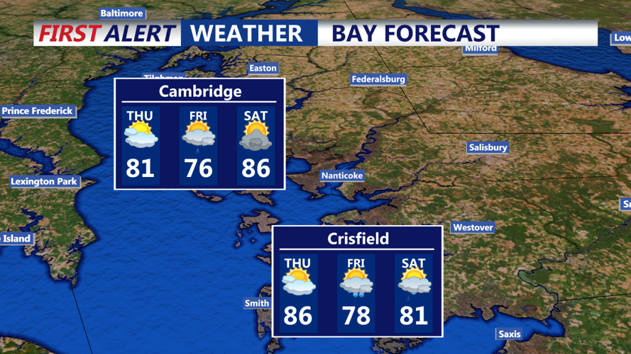
Thursday morning will start with cooler conditions across Delmarva, with lows tonight expected to dip into the 70s in southern parts and the 50s in the northern areas. As the cold front clears, temperatures will struggle to climb, with afternoon highs reaching only into the 80s in southern Delmarva and the 70s further north. Low clouds and possibly some light mist or drizzle could linger through much of the day, especially in the morning.
There is some uncertainty about how much storm activity, or convection, we might see from the front’s passage tonight. Given the timing of the front’s arrival, any storms are likely to be driven more by upper-level instability and forcing rather than the front itself. Scattered storms may develop late this afternoon and expand across the region this evening as an approaching shortwave trough moves in. As instability wanes toward dawn, most of the precipitation is expected to diminish, but some light mist or drizzle may continue, particularly in the morning.
Damaging winds remain the primary risk with any storms that do develop tonight, due to high Convective Available Potential Energy (CAPE) and Downdraft CAPE (DCAPE) levels. There is also a chance for locally heavy rain or small hail. By early Friday, most precipitation should be out of the area, but spotty convection could still develop in the warm sector west of us later on Thursday, potentially moving in but weakening as it encounters the cooler air mass over Delmarva.
Stay tuned for further updates, especially concerning storm risks tonight and the expected cooling trend through Thursday.
