


DELMARVA TONIGHT
Expect a very warm and muggy night with lows primarily in the low to mid-70s. Patchy fog is likely to develop across the region, particularly in areas that experienced showers and thunderstorms earlier.
Saturday's Forecast:
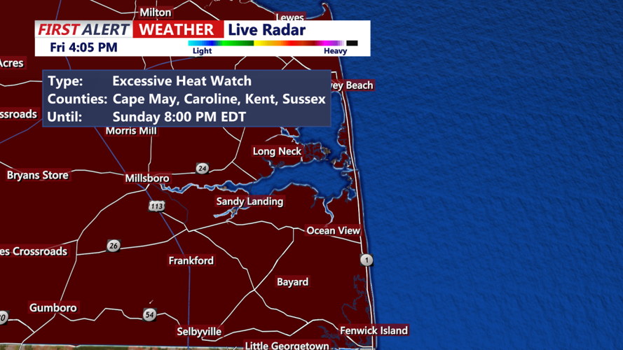
Forecast high temperatures for Saturday have slightly decreased, but the overall weather pattern remains unchanged, characterized by increasing warm air advection. The Excessive Heat Watch previously issued for the I-95 corridor has been replaced with a Heat Advisory. The I-95 areas are expected to reach highs in the mid to upper 90s, with heat indices staying within advisory criteria at best.
- Morning: Temperatures will quickly rise from the 70s to the 80s with increasing humidity. Expect partly sunny skies.
- Afternoon: Highs will peak in the mid to upper 90s. Heat indices will make it feel hotter, likely in the 100-105°F range. Scattered showers and thunderstorms are expected, similar to today's pattern.
- Evening: Temperatures will remain warm, in the 80s, with continued chances of showers and thunderstorms.
Heat Safety Tips:
- Avoid Strenuous Activities: Limit intense physical activities, especially during the hottest parts of the day. Schedule workouts or outdoor chores for early morning or late evening.
- Use Fans and Air Conditioning: Utilize fans and air conditioning to help keep your home cool. If you do not have air conditioning, seek out cool public spaces like libraries or shopping malls.
- Check on Vulnerable Individuals: Ensure that the elderly, children, and pets are staying cool and hydrated. Never leave children or pets in a parked car.
Stay tuned to local weather updates for the latest information on the heat advisory and any further weather developments. Be prepared for the possibility of showers and thunderstorms throughout Saturday afternoon into Saturday night.