


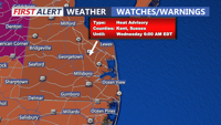

DELMARVA - The National Weather Service has issued a Heat Advisory for Sussex County and all of the Delaware coast from Monday to Wednesday morning. In addition for Dorchester, Somerset, Wicomico and Worcester counties in Maryland. Heat Indices expected to rise as highs as 110 over the next three days.
Remember to take it easy, limit time outdoors especially during the hottest part of the day, stay hydrated, stay in air conditioning and wear loose light fit clothing.
Monday afternoon will be a scorcher on Delmarva with highs reaching the upper 90s and heat indices ranging from 103 to 108 degrees. Severe storms are expected north and west of Delmarva but can't rule out a stray thunderstorm moving through later today through the evening. Some storms can pack gusty winds, but most of the region will stay dry.
Tuesday looks to be the hottest and worst day of the heatwave with temperatures approaching 100 degrees and heat indices ranging from 106 to 110. In fact, we are expecting triple digit heat indices at the coast as well all thanks to a southwesterly wind. Again, can't rule our an isolated evening storm, most of Delmarva will stay dry and hot.
Wednesday will be the final day of the heatwave with temperatures in the mid to upper 90s, heat indices once again in the 104 to 110 range. A cold front will be moving closer to the area and a better chance of showers and storms will move in during the late afternoon early evening time frame. Some of these storms can pack some gusty winds.
Thursday will have a few scattered showers, still humid with highs only in the low 80s. Friday is when we see big relief from the humidity as dew points fall into the 50s behind the front. Friday certainly looks like the pick of the week.