


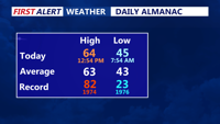


DELMARVA - High pressure remains firmly in control across Sussex County through Sunday afternoon, keeping skies mostly clear and conditions tranquil. Temperatures will rise into the upper 50s under a light southwest breeze before winds calm overnight.
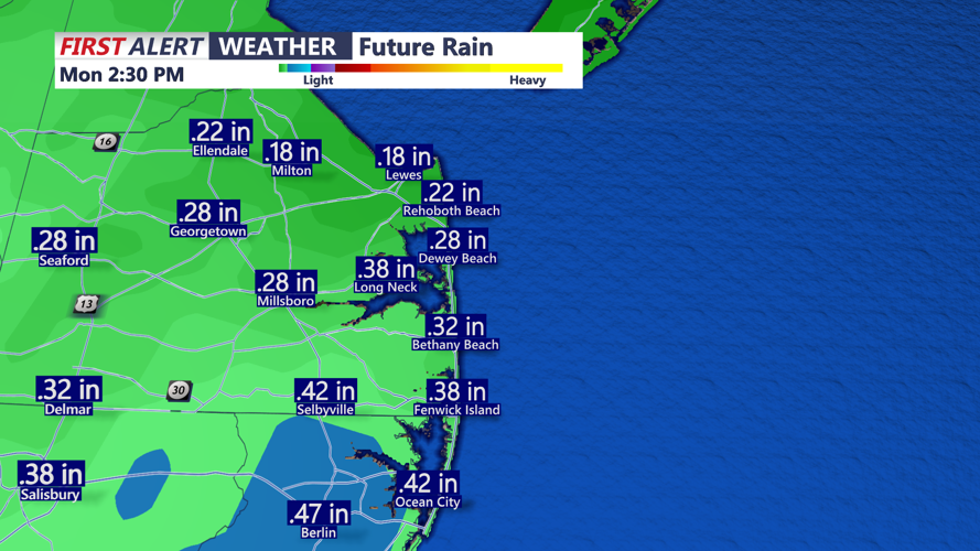
Clouds will gradually thicken tonight as a weak coastal low develops off the Southeast coast and tracks northward on Monday. While the system is expected to stay well offshore, its outer bands could bring a few light showers to Delaware’s beaches early Monday, with only spotty sprinkles possible farther inland. Rainfall totals will remain light, generally less than one-tenth of an inch.
Highs Monday will reach the upper 50s to around 60 degrees. By Monday night, the low moves away and a weak cold front slides through the region. Clearing skies and calm winds will follow as high pressure returns Tuesday into Wednesday, bringing plenty of sunshine and seasonable temperatures.
Lows Monday night will dip into the upper 30s and low 40s, with the potential for patchy frost in rural inland areas by Tuesday night. Highs Tuesday will climb into the upper 50s to low 60s before another cold front approaches Wednesday night.
Looking ahead, high pressure briefly rebuilds Thursday and Friday, keeping skies mostly clear before a stronger system moves in next weekend, bringing the potential for widespread rain and unsettled weather.