


DELMARVA -- The rest of Monday will bring hot and mostly dry conditions to Delmarva as high pressure builds in from the Ohio Valley. Fair skies and light north winds will dominate, with a sea breeze developing along the coast by afternoon.

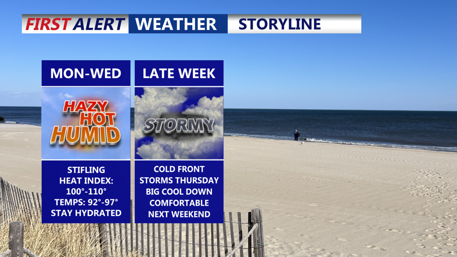
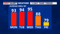
Temperatures will climb into the 90s, and with dew points in the low 70s, heat index values will push into the upper 90s and to near 100 this afternoon. While these numbers fall just short of official heat advisory criteria, they will still present uncomfortable conditions for outdoor activities.

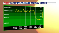
Overnight, we're looking at warm and muggy conditions, with temperatures only dropping into the low 70s.

Looking ahead to Tuesday and Wednesday, heat and humidity will intensify. Highs are forecast to reach the mid to upper 90s both days, with dew points in the low to mid 70s driving heat index values between 100 and 105 degrees. The peak heat is expected on Wednesday, and heat headlines may be issued as conditions could become dangerous. Heat index values could approach 110 for some locations on Wednesday.
A strong cold front will approach Thursday, bringing an increased risk of showers and thunderstorms. While the timing of the front’s arrival could limit the severity of storms if it passes through at night, heavy rainfall and flash flooding will still be possible, especially with moisture levels running high. Portions of the region are under a marginal to slight risk of excessive rainfall midweek.

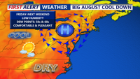
By Friday, lingering showers are possible, with conditions improving later on Friday. High temperatures will be in the upper 70s to near 80.

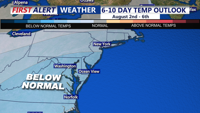
Strong high pressure builds into the region over the weekend, with cooler and drier air settling over the area, dropping temperatures 5 to 10 degrees below average, a welcome break after a hot start to the week. It will feel really good as we begin the month of August. Highs both weekend days ill be in the upper 70s and low 80s.