


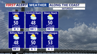


DELMARVA- Today is the warmest day of the weekend. Expect mostly sunny skies with inland highs pushing to around 60. If you’re heading to the coast, plan on a cooler afternoon at the beaches, where temperatures hold in the 40s and 50s thanks to the ocean influence.
Late Saturday night into Sunday, an arctic front slides through Delmarva. Behind it, Sunday turns noticeably colder with an increasing northerly breeze and clouds decreasing through the day. Highs will top out in the upper 40s to around 50, but the breeze will make it feel cooler.
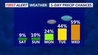
Looking ahead to Monday through midweek, the pattern becomes more active and colder air will be in place. Arctic high pressure building over the Northeast keeps Delmarva cold Monday into Tuesday, while a couple of separate systems may pass near the region. Highs Monday only in the mid 30s, then moderating temperatures Tuesday with a warm front moving through the region.
As the warm front advances towards the region, a brief period of sleet or mixed precipitation is possible across portions of the mid shore and points north, with just plain rain anticipated for coastal Delaware and Maryland. A noticeable warm up will take place for the middle to end of next week, with periodic rain showers. Forecast highs trend back into the 50s then 60s late next week into next weekend, signaling a significant warm-up for Delmarva. Looking at the long range, we could potentially see 70s by the second week of March.