


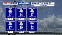


DELMARVA - Saturday begins damp and dreary, but showers taper off by midday. Skies gradually clear into the afternoon with highs in the mid 50s. Winds turn north-northwest at 10 to 20 mph, ushering in cooler, drier air by Saturday night. Lows Saturday night fall into the low to mid 30s under clear skies.

Sunday we'll see a mix of sun and clouds as high pressure settles over the area. Highs reach the mid to upper 50s with a west-southwest breeze at 5 to 10 mph. Sunday night stays dry and chilly with lows generally in the 30s as a weak disturbance passes to the north.

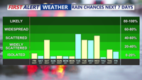
Looking ahead to early next week, seasonable and quiet weather continues Monday with highs in the upper 50s to near 60. A warming trend sets in Tuesday into Wednesday ahead of the next frontal system, bringing increasing rain chances by late Tuesday and Tuesday night. Wednesday we'll see mainly morning showers with mild highs into the 60s.

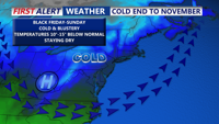
Forecast confidence decreases toward Thanksgiving as models diverge on the timing and evolution of a strong cold front. A slower-moving system could mean a warmer, wetter Thanksgiving with highs in the 50s to low 60s, while a faster front would bring a colder, drier holiday, with highs only in the 40s and 50s. Much colder air is expected to settle in by next Friday and persist through the holiday weekend.
