


DELMARVA - The weather forecast for Delmarva over the next few days is marked by a series of dynamic and impactful weather systems, making for a particularly unsettled period.
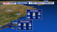
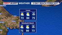
Tuesday: The day starts with weak low pressure just east of Delaware, causing showers and isolated thunderstorms through the morning. These are expected to decrease by lunchtime as the low pressure system moves offshore. However, precipitation chances will not drop to zero; there might still be occasional showers throughout the day. The afternoon will see temperatures rising into the 70s.
Tuesday Night through Wednesday: A new area of low pressure from the Great Lakes moves towards the Ohio Valley, pulling a warm front up towards Delmarva. This setup leads to scattered showers and thunderstorms developing Tuesday evening, which will become more likely overnight and into Wednesday morning as the warm front lifts through the region. By midday Wednesday, precipitation should taper off, leading to a warm and humid afternoon with highs in the mid to upper 80s, except cooler temperatures in the 70s along the coasts. Dew points will also rise, enhancing the muggy feel.
Thursday: The weather remains active with a secondary low pressure developing ahead of the primary system. This will result in more widespread showers and scattered thunderstorms across the region by Thursday afternoon and evening. The potential for strong to severe thunderstorms exists, especially south of the warm front, though the exact progression of the front will greatly influence where these storms occur and their severity. High temperatures for Thursday will vary significantly, ranging from the low to mid-60s north of the front, to the mid to upper 70s south of it. The system is expected to shift offshore by Thursday night, reducing the chances of precipitation.
