


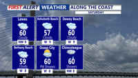
A storm system well off the coast is spreading a few showers into coastal areas, with the rest of the area staying just cloudy. Much cooler with highs only near 60.
From
To

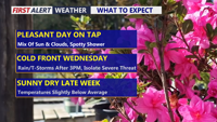
Delmarva will see a pleasant and mainly dry Tuesday with partly sunny skies and only a slight chance for an isolated shower or sprinkle. Temperatures will be mild inland, cooler along the coast, and partly cloudy skies continue tonight. Wednesday stays mild ahead of a strong cold front, with much-needed rain developing later in the day and continuing into early Thursday. A stronger thunderstorm cannot be ruled out, but the overall risk remains low.


A dry and unseasonably warm Thursday in Sussex County is expected to give way to cooler conditions by early Friday as a backdoor cold front moves into the region.

Light rain and patchy fog late tonight are expected to give way to a dry, warmer Thursday across Sussex County.

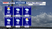
Light showers will affect Sussex County early Wednesday before drier weather arrives Wednesday night into early Thursday.

Light showers are expected in Sussex County, Delaware, from late Tuesday night into Wednesday morning before skies begin to brighten late Wednesday.


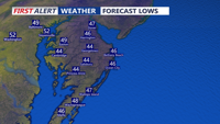
DELMARVA - Tonight, as a southerly breeze develops, clouds increase a bit and temperatures will be a bit milder, with low to mid 50s. Temperat…


Clouds and fog are expected to linger in Sussex County from late Thursday night into much of Friday morning before warmer air pushes in and lifts temperatures well into the 70s by late Friday afternoon.


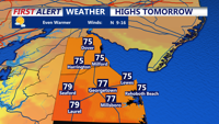
Today looks to be the warmest day of the stretch, with partly cloudy skies, and inland highs reaching the low to mid 80s.

Sussex County is expected to stay mainly dry from early Thursday morning through Friday morning as temperatures begin to warm.