


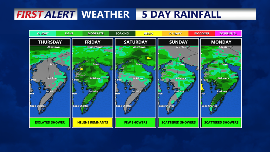


DELMARVA -- A warm front is lifting through Delmarva bring the return of milder air and slightly muggy conditions. As we move into tonight a cold front will approach from the west, setting the stage for an unsettled weather through the weekend.
Despite the cloud cover this afternoon temperatures will remain relatively mild, with highs ranging from the mid to upper 70s at the coast to low 80s across inland areas. Can't rule out an isolated shower, most of the area stays dry during the day. Winds will be light, coming from the southeast at 5 to 10 mph, though coastal areas may experience slightly stronger gusts up to 15 mph.
Coastal Flood Advisories continue through tonight for Sussex Co. HIGH risk for rip currents today and a MODERATE risk Friday as waves will be 2 to 3 feet.
Friday will feature continued cloud cover with temperatures in the mid 70s, we watch moisture begin to stream into the peninsula Friday evening into Saturday morning. Some tropical downpours are possible.

The unsettled weather pattern is expected to continue into the weekend, with showers and cooler temperatures persisting as remnants of what is now Hurricane Helene could bring additional moisture to the area. Rainfall looks to be in the inch and a half to inch range between Friday Night - Saturday PM.