


DELMARVA -- Tonight, a warm front will track through the Delmarva region, bringing a blanket of clouds and mild overnight temperatures. Lows will range in the upper 60s to near 70. Winds will primarily come from the southeast at 5 to 10 mph, increasing to 10 to 15 mph along the coast.
Afternoon highs tomorrow will vary from around 80 degrees inland to mid to upper 70s at the coast, with clouds remaining plentiful throughout the day. Can't rule our a spotty shower.
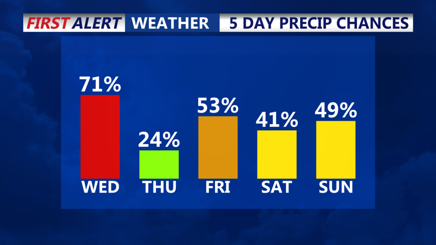
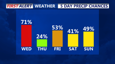
Looking ahead to Thursday night through Saturday, expect continued unsettled conditions. Models suggest that moisture from the remnants of Tropical Storm Helene may get drawn northward, interacting with an upper-level low in the Tennessee Valley. This could lead to additional showers across Delmarva, with temperatures staying slightly above normal for this time of year. Highs will range from the mid 70s, with lows generally in the 60s.

The long-term forecast, covering Saturday night through Wednesday, remains uncertain. Models disagree on how the remnants of Helene will behave as they move into the Tennessee Valley. While some solutions keep the region relatively dry with scattered showers, others suggest a wetter scenario, particularly on Sunday and Sunday night, when chances for rain may increase for Delmarva and southern New Jersey.
As we move into early next week, temperatures will remain close to seasonal norms, with highs in the upper 60s to low 70s and lows in the 50s to low 60s along the coast. Be prepared for fluctuating weather conditions as we navigate through this unsettled period.