


DELMARVA - Sunday will start with low clouds and patchy fog in the morning, but conditions will improve to a warm and muggy day for Delmarva.
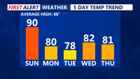
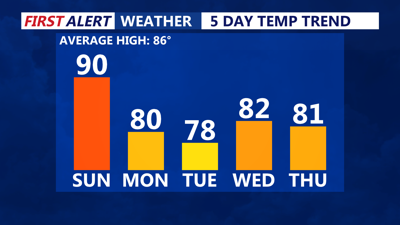
During the day on Sunday, the high will move farther out to sea as a cold front approaches from Canada. Southerly winds will draw warmer, more humid air into the region, pushing highs back into the upper 80s to near 90. Dew points will once again climb into the upper 60s to near 70.

An isolated shower or storm is possible late Sunday afternoon into the evening as the front passes through. However, storm coverage is expected to remain limited, with a low risk for severe weather or flooding. Any lingering showers will move offshore Sunday night as high pressure builds in from the north. Overnight lows will fall into the 60s to near 70.
The cold front will stall over the Mid-Atlantic early in the week as Canadian high pressure builds in from Quebec and New England. Persistent onshore winds Monday and Tuesday will usher in cooler air, keeping highs in the mid-70s to low 80s Monday and dropping temperatures even further on Tuesday.
An upper-level disturbance could bring showers and thunderstorms Tuesday night, followed by drier conditions the rest of the week.

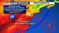
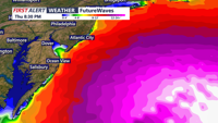
WATCHING HURRICANE ERIN — Hurricane Erin, currently north of Puerto Rico and the Virgin Islands, may bring coastal hazards to Delmarva next week. A high risk for rip currents, rough surf, and possible minor coastal flooding starting Tuesday and lasting into Thursday. Residents and beachgoers should stay alert to updates.
