


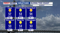
The showery and breezy conditions continue this evening with temperatures in the 50s.
From
To

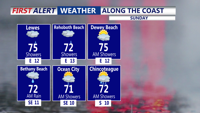
A warm up kicks in today with a strong southwesterly flow. Temperatures top out in the mid 70s, with cooler conditions at the coast.


The warmer and drier weather has raised brush fire concerns in Sussex county.

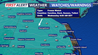
The chilly weather pattern continues, with a Freeze Watch Tuesday night into Wednesday morning.

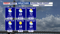
As high pressure shifts to our east today, a return flow will develop and warmer air will start to move back into the region.

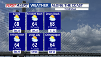
Big warm up today with 70s, then rainy and colder conditions Friday.

A weakening cold front may still bring scattered showers and perhaps even a thunderstorm this afternoon and evening.

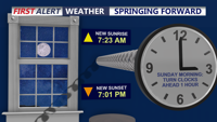
Remember to set your clocks ahead one hour tonight as we start Daylight Saving Time.


With the warmer weather and melting snow, more potholes will appear, and that means more to fix for DelDOT and mechanics.


After weeks of snow-covered fields and freezing temperatures, a recent warm spell is giving gardeners and farmers a small taste of spring.