




...COASTAL FLOOD ADVISORY REMAINS IN EFFECT FROM 4 PM TO 10 PM
EDT TUESDAY...
...COASTAL FLOOD WATCH REMAINS IN EFFECT FROM WEDNESDAY AFTERNOON
THROUGH LATE THURSDAY NIGHT...
* WHAT...For the Coastal Flood Advisory, up to one foot of
inundation above ground level expected in low-lying areas near
shorelines and tidal waterways. For the Coastal Flood Watch,
one to two feet of inundation above ground level possible in
low- lying areas near shorelines and tidal waterways.
* WHERE...Kent and Inland Sussex.
* WHEN...For the Coastal Flood Advisory, from 4 PM to 10 PM EDT
Tuesday. For the Coastal Flood Watch, from Wednesday afternoon
through late Thursday night.
* IMPACTS...At this level, widespread roadway flooding occurs in
coastal and bayside communities and along inland tidal
waterways. Many roads become impassable. Some damage to
vulnerable structures may begin to occur.
* ADDITIONAL DETAILS...Moderate tidal flooding could continue
through at least Friday evening's high tide or perhaps longer.
PRECAUTIONARY/PREPAREDNESS ACTIONS...
A Coastal Flood Watch means that conditions favorable for
flooding are expected to develop.
Be prepared to begin taking appropriate action to protect life
and property. Follow the recommendations of local emergency
management officials. Be sure to check the latest forecast from
time to time in case a warning is issued or any new information
becomes available.
Visit the National Water Prediction Service at
https://water.noaa.gov/wfo/phi for additional water level and
flood impact information for your local tide gauge.
&&
Time of high total tides are approximate to the nearest hour.
Murderkill River at Bowers Beach
MLLW Categories - Minor 6.6 ft, Moderate 7.6 ft, Major 8.6 ft
MHHW Categories - Minor 0.9 ft, Moderate 1.9 ft, Major 2.9 ft
Total Total Departure
Day/Time Tide Tide from Norm Flood
ft MLLW ft MHHW ft Impact
-------- --------- --------- --------- --------
21/06 PM 6.4 0.7 0.9 None
22/07 AM 5.8 0.1 1.3 None
22/07 PM 7.1 1.4 1.4 Minor
23/08 AM 6.5 0.8 1.7 None
23/08 PM 7.8 2.1 1.9 Moderate
24/08 AM 7.0 1.3 1.8 Minor
Delaware Bay at Lewes
MLLW Categories - Minor 6.0 ft, Moderate 7.0 ft, Major 8.0 ft
MHHW Categories - Minor 1.3 ft, Moderate 2.3 ft, Major 3.3 ft
Total Total Departure
Day/Time Tide Tide from Norm Flood
ft MLLW ft MHHW ft Impact
-------- --------- --------- --------- --------
21/06 PM 5.8 1.2 1.4 None
22/06 AM 5.3 0.7 1.7 None
22/06 PM 6.5 1.8 2.0 Minor
23/07 AM 6.1 1.5 2.2 Minor
23/07 PM 7.1 2.5 2.4 Moderate
24/08 AM 6.5 1.8 2.4 Minor
&&
Weather Alert
...COASTAL FLOOD ADVISORY REMAINS IN EFFECT FROM 4 PM TO 10 PM
EDT TUESDAY...
...COASTAL FLOOD WATCH REMAINS IN EFFECT FROM WEDNESDAY AFTERNOON
THROUGH LATE THURSDAY NIGHT...
* WHAT...For the Coastal Flood Advisory, up to one foot of
inundation above ground level expected in low-lying areas near
shorelines and tidal waterways. For the Coastal Flood Watch,
one to two feet of inundation above ground level possible in
low- lying areas near shorelines and tidal waterways.
* WHERE...Kent and Inland Sussex.
* WHEN...For the Coastal Flood Advisory, from 4 PM to 10 PM EDT
Tuesday. For the Coastal Flood Watch, from Wednesday afternoon
through late Thursday night.
* IMPACTS...At this level, widespread roadway flooding occurs in
coastal and bayside communities and along inland tidal
waterways. Many roads become impassable. Some damage to
vulnerable structures may begin to occur.
* ADDITIONAL DETAILS...Moderate tidal flooding could continue
through at least Friday evening's high tide or perhaps longer.
PRECAUTIONARY/PREPAREDNESS ACTIONS...
A Coastal Flood Watch means that conditions favorable for
flooding are expected to develop.
Be prepared to begin taking appropriate action to protect life
and property. Follow the recommendations of local emergency
management officials. Be sure to check the latest forecast from
time to time in case a warning is issued or any new information
becomes available.
Visit the National Water Prediction Service at
https://water.noaa.gov/wfo/phi for additional water level and
flood impact information for your local tide gauge.
&&
Time of high total tides are approximate to the nearest hour.
Murderkill River at Bowers Beach
MLLW Categories - Minor 6.6 ft, Moderate 7.6 ft, Major 8.6 ft
MHHW Categories - Minor 0.9 ft, Moderate 1.9 ft, Major 2.9 ft
Total Total Departure
Day/Time Tide Tide from Norm Flood
ft MLLW ft MHHW ft Impact
-------- --------- --------- --------- --------
21/06 PM 6.4 0.7 0.9 None
22/07 AM 5.8 0.1 1.3 None
22/07 PM 7.1 1.4 1.4 Minor
23/08 AM 6.5 0.8 1.7 None
23/08 PM 7.8 2.1 1.9 Moderate
24/08 AM 7.0 1.3 1.8 Minor
Delaware Bay at Lewes
MLLW Categories - Minor 6.0 ft, Moderate 7.0 ft, Major 8.0 ft
MHHW Categories - Minor 1.3 ft, Moderate 2.3 ft, Major 3.3 ft
Total Total Departure
Day/Time Tide Tide from Norm Flood
ft MLLW ft MHHW ft Impact
-------- --------- --------- --------- --------
21/06 PM 5.8 1.2 1.4 None
22/06 AM 5.3 0.7 1.7 None
22/06 PM 6.5 1.8 2.0 Minor
23/07 AM 6.1 1.5 2.2 Minor
23/07 PM 7.1 2.5 2.4 Moderate
24/08 AM 6.5 1.8 2.4 Minor
&&
Weather Alert
...SMALL CRAFT ADVISORY REMAINS IN EFFECT FROM 5 AM TUESDAY TO
6 AM EDT WEDNESDAY...
...GALE WATCH REMAINS IN EFFECT FROM WEDNESDAY MORNING THROUGH
THURSDAY AFTERNOON...
* WHAT...For the Small Craft Advisory, northeast winds 15 to 25
kt with gusts up to 35 kt and rough waters expected. For the
Gale Watch, northeast winds 20 to 30 kt with gusts up to 40 kt
and very rough waters possible.
* WHERE...Delaware Bay waters north of East Point NJ to
Slaughter Beach DE and Delaware Bay waters south of East Point
NJ to Slaughter Beach DE.
* WHEN...For the Small Craft Advisory, from 5 AM Tuesday to 6 AM
EDT Wednesday. For the Gale Watch, from Wednesday morning
through Thursday afternoon.
* IMPACTS...Strong winds can cause hazardous seas which could
capsize or damage vessels and reduce visibility.
PRECAUTIONARY/PREPAREDNESS ACTIONS...
Mariners should consider altering plans to avoid possible
hazardous conditions. Remain in port, seek safe harbor, alter
course, and/or secure the vessel for severe wind and seas.
&&
Weather Alert
...SMALL CRAFT ADVISORY REMAINS IN EFFECT FROM 5 AM TUESDAY TO
6 AM EDT WEDNESDAY...
...GALE WATCH REMAINS IN EFFECT FROM WEDNESDAY MORNING THROUGH
THURSDAY AFTERNOON...
* WHAT...For the Small Craft Advisory, northeast winds 15 to 25
kt with gusts up to 35 kt and rough waters expected. For the
Gale Watch, northeast winds 20 to 30 kt with gusts up to 40 kt
and very rough waters possible.
* WHERE...Delaware Bay waters north of East Point NJ to
Slaughter Beach DE and Delaware Bay waters south of East Point
NJ to Slaughter Beach DE.
* WHEN...For the Small Craft Advisory, from 5 AM Tuesday to 6 AM
EDT Wednesday. For the Gale Watch, from Wednesday morning
through Thursday afternoon.
* IMPACTS...Strong winds can cause hazardous seas which could
capsize or damage vessels and reduce visibility.
PRECAUTIONARY/PREPAREDNESS ACTIONS...
Mariners should consider altering plans to avoid possible
hazardous conditions. Remain in port, seek safe harbor, alter
course, and/or secure the vessel for severe wind and seas.
&&
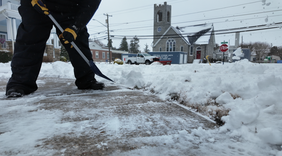
Plow crews and neighbors in Selbyville were kept busy with the snowfall Sunday morning.Â
Alike the beaches down the coast in Fenwick Island, the beaches of Bethany Beach were covered with the mixture of precipitation as waves rolled almost all the way up to the dunes.Â
Drew Bellinger joined the CoastTV News team in August 2025 as a
video journalist. Before earning a Bachelor’s degree in
Communications from Towson University in 2024, he completed a
General Studies Associate's degree program from the Community
College of Baltimore County.
SUSSEX COUNTY, Del. - Conditions on the roads and over the dunes varied after Sussex County saw a considerable snowfall this weekend.
Â
Mother Nature was in full force in Sussex County on Sunday after the snowfall covered most of the area, eventually changing over to a sleet and rain mixture throughout the day. Road conditions and conditions over the dunes varied throughout towns along the coast.
Â
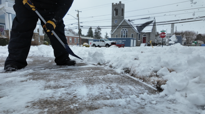
Early Sunday morning, plow crews and neighbors in Selbyville were actively maintaining streets and sidewalks.
Â
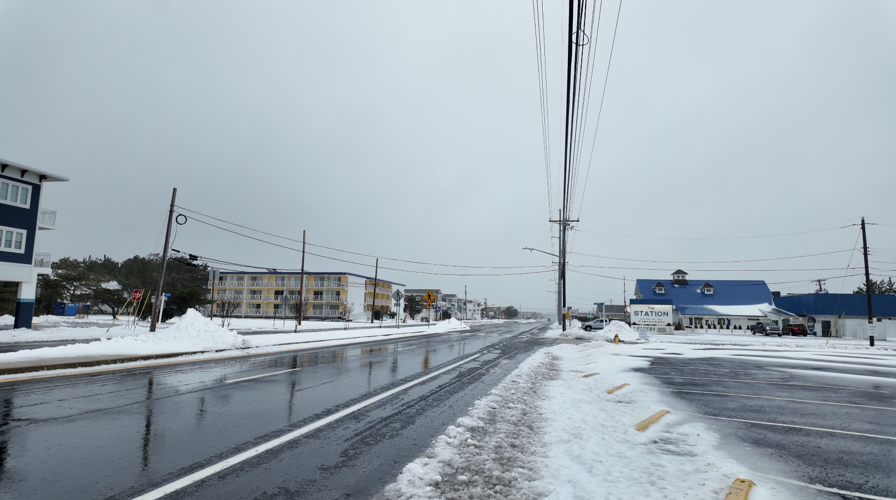
Further down Lighthouse Road in Fenwick Island, the streets of Route 1 had been maintained in a passable condition, but were slick after the snow turned to a rain/sleet mixture.
The streets of major highway Route 1 in Fenwick Island were slick.Â
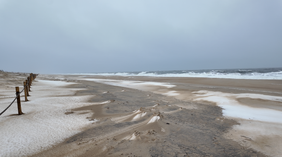
The beaches in Fenwick Island saw whipping winds. A mixture of snow, sleet, rain, and sand flew through the air, and waves crashed.
It was not a typical sunny day on the beaches of Fenwick Island. A mixture of snow, rain, sleet, sea mist, and sand was flying through the air.Â
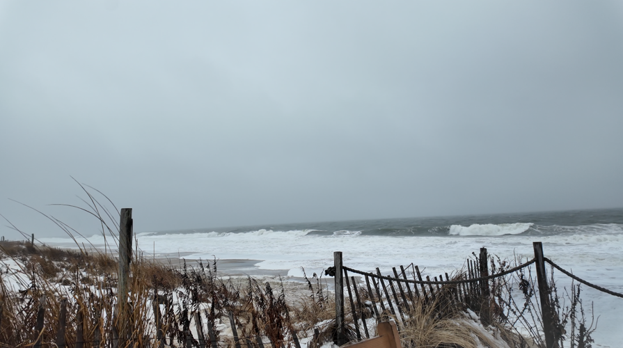
The stretch of Route 1 in South Bethany and Bethany Beach saw more slush but were similarly slick. The beaches of Bethany Beach saw waves that came almost all the way up to the dunes.
Alike the beaches down the coast in Fenwick Island, the beaches of Bethany Beach were covered with the mixture of precipitation as waves rolled almost all the way up to the dunes.Â
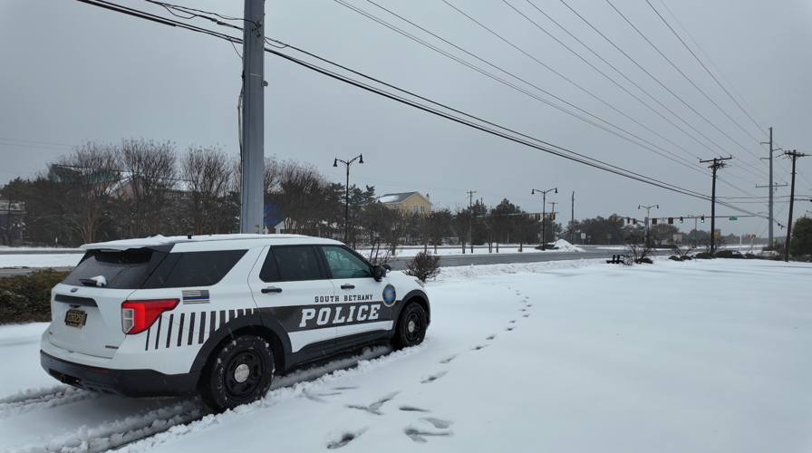
Corporal Tyler Bare with the South Bethany Police Department said there had been little to no accidents in town, but the department would be monitoring the main stretch.
Â
"Not too much, not in town. There's been a very minimal amount of traffic coming through town. Monitor mainly the highway, side streets as well," said Corporal Bare. "Our town maintenance guys have been doing amazing since the wee hours of the morning, tackling out the snow. It was a very powder like (snow), so the wind coming off the ocean caused it to just blow up to a foot tall in certain areas. Which caused a little problem at first. But these guys got it plowed, got it cleared. So far, no accidents in town right now, just monitoring everything and keeping it flow, keeping it steady."
Get our all-good news weekly newsletter
FEEL GOOD FRIDAY
Success! An email has been sent to with a link to confirm list signup.
Error! There was an error processing your request.
Some officers with the South Bethany Police Department spent Sunday patrolling Coastal Highway.Â
Corporal Bare says Sunday's nasty conditions caused accidents in other parts of Sussex County, which is only more reason for people to take the day off unless absolutely necessary.
Â
DelDOT officials told CoastTV on Saturday that the major highways would be treated first.
Â
Main roads such as Route 1 and Route 54 were slick yet passable early Sunday morning, but some neighbors CoastTV spoke with, like Matthew McCollum, said they only left the house once the weather calmed down in the afternoon.
Â
"We stayed home," said McCollum. "We had a little brunch, (ate) a little chili, (ate) some ribs my wife had made. Then we thought we would go out and watch some football."
Â
McCollum expressed concerns about icy road conditions on Monday, with temperatures dropping and the roads staying wet.
After snow turned to a downpour of rain later in the day, the streets of Selbyville remained quiet.Â
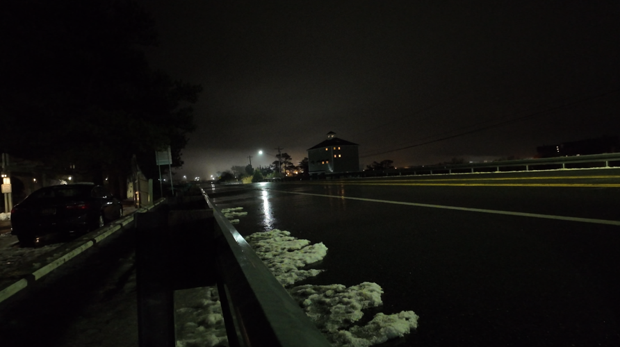
As the day went on, the snow that landed overnight Saturday turned into a snow and sleet mixture. This kept the majority of the people in town off the roadways. However, DelDOT crews were seen out at night treating the roadways with salt and further clearing areas of the roads, such as turn lanes.
While most remained hunkered down, DelDOT crews continued to work throughout the day on Sunday.Â
Stay up to date on the latest weather with radar and hourly forecasts in the CoastTV weather app, available for Apple and Android.
Drew Bellinger joined the CoastTV News team in August 2025 as a
video journalist. Before earning a Bachelor’s degree in
Communications from Towson University in 2024, he completed a
General Studies Associate's degree program from the Community
College of Baltimore County.