


DELMARVA - We have been tracking Monday night's storms since early evening. There was a great amount of thermodynamic energy in place prior to the storm's arrival. It began to show early signs of circulation and potential for turning tornadic.
Ultimately, it has begun to move and develop quickly. There was an isolated pocket in western and northwestern portions of Sussex County, the same pocket of Bridgeville and Greenwood that was hit by a tornado in April, that was placed briefly under a tornado warning until about 8 p.m.
Video from a WRDE Coast TV news anchor, who was caught in the storm at the Royal Farms in Greenwood about 8 p.m.
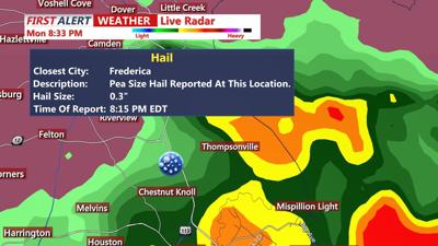
Radar has indicated a tornado producer period with winds of up to 80 mph and nearly one-and-a-half-inch to two-inch diameter hail. Heavy downpours can cause localized flash flooding in some areas. The storm is moving northeast.
Throughout Monday night we will see isolated pockets of spotty showers flaring up occasionally. Though more tornado warnings are unlikely as the storm has already used up that energy, there is still enough in place for the possibility of severe storms. We will remain under a severe thunderstorm watch until 10 p.m.
Areas of flooding concern include the Hurlock and Mardela Springs areas. Several storms may hit the same area here and in western Sussex County over and over. A flood warning will remain in effect until 11:15 p.m. for northern Dorchester and Wicomico counties.
Keep an eye on our Facebook and Twitter for live updates in English and Spanish.