


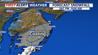
Light to moderate rain moves across Delmarva this afternoon into the evening with temperatures in the mid 40s, then exits later tonight. Friday turns bright and milder near 50, with Saturday the pick of the weekend near 60 and sunshine. A dry front slips through Sunday, and we’re monitoring the potential for accumulating snow Monday night into Tuesday morning, though confidence remains low for now.
From
To

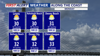
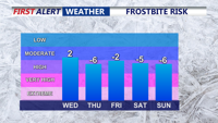
A Cold Weather Advisory covers Sussex County through Monday morning as wind chills stay near or below zero, with clouds increasing and temperatures moderating by early Tuesday


The dangerous cold stretch continues for Delmarva for the rest of the weekend and into the start of the new week.

The dangerous cold stretch continues for Delmarva for the rest of the weekend and into the start of the new week.

Temperatures above freezing much of the week with light snow from clipper systems.

The powerful ocean storm continues to move away from the east coast with diminishing impacts.

Delmarva stays locked in arctic cold today with highs only in the low to mid 20s under increasing clouds, flirting with record territory near Georgetown. Light snow and flurries arrive this evening and overnight, with the best chance for measurable snow remaining in far southern and coastal areas, especially Accomack County. The bigger story is a rapidly strengthening storm offshore that will bring bitter wind chills and the risk of minor coastal flooding during the Sunday morning high tide

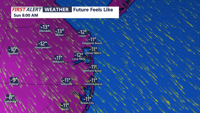
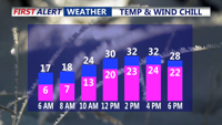
Bitterly cold out the door this morning with temperatures in the upper single digits and teens with feels like temperatures below zero in some locations.

Delmarva is heading into a prolonged stretch of dangerous, bone-chilling cold, as an Arctic air mass locks in for the remainder of the week and may linger into the weekend.


Refreezing is expected to keep travel slick early Monday in Sussex County, and another surge of arctic air is forecast to reinforce dangerously cold temperatures through early Wednesday.