




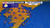
Delmarva will enjoy a mostly sunny and breezy day today with highs in the mid 70s and strong southerly gusts up to 35 to 40 mph. Showers arrive late this evening and continue overnight, with a few isolated thunderstorms possible, though severe weather is not expected. A brief unsettled stretch gives way to warmer, drier conditions by the weekend, with heat building into early next week.
From
To


Sussex County, Delaware, can expect a warm late Thursday evening followed by a chance of scattered overnight showers and a few more spotty showers Friday, with temperatures staying well above normal despite slightly cooler air near the coast.


Sussex County will stay unusually warm Thursday into early Friday, with dry, breezy conditions increasing the risk of fire spread.

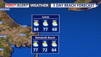
Scattered thunderstorms may brush Sussex County late Wednesday, followed by near-record warmth and elevated fire spread concerns through late Thursday.


Today brings unseasonably warm weather to Delmarva with highs in the mid 80s under mostly sunny skies, though areas near the bay and ocean will stay a bit cooler in the upper 70s to low 80s. Georgetown and Salisbury could come close to their daily record highs of 87 degrees. The warmth continues tonight and intensifies Wednesday, when record highs are likely as temperatures approach 90. Conditions stay well above normal through the weekend before shower and thunderstorm chances return Sunday ahead of a strong cold front. Much cooler air arrives next week with highs falling back into the 50s and 60s.

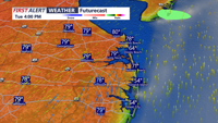
Sussex County is expected to stay warm and mainly dry from early Tuesday into early Wednesday, with only a limited chance of a passing late-day shower or storm Tuesday.

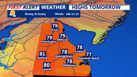
Sussex County should see a mild late Monday evening, a warmer Tuesday and only a limited chance of late-day showers or a weakening thunderstorm.