


A developing coastal system will bring widespread rain to Sussex County from early Tuesday through Tuesday night, followed by colder, drier weather midweek.
From
To

Delmarva can expect a calm Tuesday with highs in the low to mid-70s before a developing offshore low brings showers tonight into Wednesday. Breezy coastal winds and a HIGH risk of rip currents remain in effect from Delaware Beaches to Assateague.

Periods of rain, cooler temperatures, and breezy conditions will affect Sussex County from late Tuesday through Wednesday night, with showers lingering into Thursday.

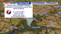
An EF-1 tornado with winds up to 110 mph struck Dorchester County, Md., and Sussex County, Del., Friday evening, damaging trees and homes along an 11.4-mile path from near Rhodesdale to south of Bethel. No injuries were reported. Sunday brought sunny, breezy conditions to Delmarva. A cold front moves in Sunday night, followed by a dry and pleasant start to the week. Rain returns Wednesday with cooler temperatures and unsettled weather through Saturday.

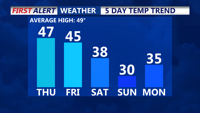
High pressure will deliver calm and seasonable weather to Delmarva on today, with mostly sunny skies and highs in the upper 40s. Clouds will build overnight as a new system approaches, bringing a chance of light rain and snow showers Friday into Friday night. The weekend ushers in colder, blustery conditions, with highs in the 20s to 30s, and arctic air settling into early next week.

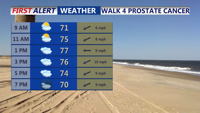
Delmarva residents can expect a mix of misty mornings, low clouds, and scattered showers starting Sunday. Highs will range from the mid to upper 70s, with some inland areas possibly reaching 80 degrees. The weather pattern will remain unsettled due to a stalled front and the remnants of tropical moisture, leading to continued cloudy and damp conditions into midweek. Occasional rain showers are likely, especially Monday night into Tuesday, with the potential for isolated downpours. A cold front will move through by Wednesday, bringing slightly cooler but generally dry conditions for the latter part of the week.

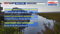
Delmarva will experience a continuation of muggy conditions tonight with areas of fog and temperatures dipping into the mid to upper 60s. The unsettled weather pattern will persist through midweek as an upper-level low and several shortwaves bring scattered showers to the region. Coastal low pressure could develop off the coast, leading to more moderate showers by Monday night into Tuesday. A cold front is expected to move through by Wednesday, followed by drier and more stable conditions towards the end of the week.