


Heavy Rain, Flash Flood Threat Thursday, Breezy and Cooler Friday for Sussex County
From
To


A stalled front lingering over the Delmarva Peninsula will keep the region humid through the weekend, with occasional showers and storms. Although conditions will ease somewhat compared to midweek, isolated flash flooding and strong wind gusts remain possible. A stronger cold front will arrive early next week, bringing more widespread storms and a gradual drying trend.


The pattern remains active later this afternoon and evening, as a stationary boundary remains in the area. This boundary will act as a focus for renewed storm development. Watch for showers and storm development this evening, with the main threats being torrential rain and the potential for flash flooding.

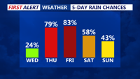
Severe storms, heavy rain and tropical humidity will persist through late Thursday evening as a slow-moving front wobbles across the region.


As Tropical Storm Debby comes towards Delaware, AAA gives drivers safe driving tips during the extreme weather.


A slow-moving cold front will bring rain and potential fog tonight before stalling over the Mid-Atlantic. Expect clearer skies and drier conditions by tomorrow morning.


Heavy showers and thunderstorms are expected to intensify over Delmarva starting overnight, with significant rainfall and potential flash flooding through Saturday afternoon.