


A hard freeze is expected inland Monday night, while Sussex County’s beach communities stay colder than normal but likely above freezing before milder air returns Tuesday.
From
To

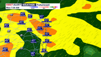
Today starts a much cooler stretch across Delmarva with mostly cloudy skies, highs in the mid 50s, and gusty winds. The biggest concern is tonight, when a widespread freeze is expected inland with a Freeze Warning in effect from midnight to 9 AM Tuesday. After a chilly Tuesday, temperatures rebound into the 60s and 70s by mid to late week before cooler weather and a better chance of rain return for the weekend.


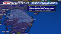
Sussex County faces a hard freeze early Wednesday, followed by another round of freeze and frost concerns Wednesday night into early Thursday.


Dry air and easing winds will give way to a cold night in Sussex County, with freezing temperatures possible by daybreak Wednesday and another round of freeze and frost concerns developing by late Wednesday evening.

A cool and breezy Tuesday is ahead across Delmarva with afternoon highs in the mid 50s and northwest wind gusts of 30 to 35 mph. The combination of dry air and gusty winds will create an elevated risk for fire spread, though recent rainfall may help limit the overall threat. Colder air settles in tonight and lingers through Thursday morning, bringing freeze and frost concerns away from the immediate coast. After the chilly stretch, temperatures rebound quickly late week, with 70s returning by Friday and 80s possible early next week.


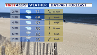
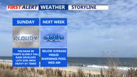
From Wednesday morning through Friday morning, beach towns in Sussex County, Delaware, and Ocean City, will experience below-normal temperatures, increased cloud cover, and the first signs of unsettled weather later in the week.


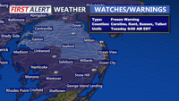
Sub-freezing temperatures are expected across Sussex County, Delaware, and Ocean City, Maryland, from late Tuesday through Wednesday morning, prompting a Freeze Warning and a call for cold-weather precautions.

A stalled front and incoming low pressure will bring widespread rain to Delmarva Sunday night into Monday. Expect up to 1.5 inches of rainfall, a sharp temperature drop, and gusty winds by midweek. After a brief dry spell, unsettled weather returns late Thursday into the weekend, with a chance of a nor’easter developing by Saturday.

Temperatures gradual tumble Sunday afternoon after above-average warmth across Delmarva, a cold front ushers in steady rain overnight into Monday. A drastic drop in temperatures begins Monday, with widespread 40s and gusty winds expected by Tuesday. Conditions will remain dry but chilly midweek, before a potential return of rain on Friday.

Delmarva will feel a summerlike Sunday before a dramatic cooldown arrives. Highs will peak near 80 degrees inland before a cold front brings steady rain Sunday night into Monday. The week ahead features a sharp drop in temperatures, with freezing conditions and gusty winds likely by Tuesday. After a chilly midweek, more rain is possible Friday as the next system arrives.