


DELMARVA - Sussex County’s beach communities are in for a chilly stretch from late Monday evening through late Tuesday evening as an unusually cold air mass settles over the region.
Clear skies, dry air and diminishing northwest winds Monday night will create strong cooling conditions across the area. Inland sections of Sussex County are expected to drop into the low 20s to low 30s, supporting a widespread freeze and keeping Freeze Warnings in effect.
Along the immediate coast, including the beach communities, marine influence is expected to keep temperatures somewhat higher. Overnight lows there are forecast to fall into the mid to upper 30s, which should limit widespread freezing conditions, although some patchy frost remains possible.
The cold is a concern for growers and gardeners because the growing season is already active after recent warmth. Early blooms, fruit trees and other cold-sensitive plants could be vulnerable, especially away from the coast.
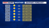
Conditions begin to improve Tuesday as high pressure shifts offshore and winds turn southerly. That change will start to moderate temperatures, and it is not expected to be as cold Tuesday night as clouds increase and the air mass begins to warm.
The broader warming trend is expected to continue through the second half of the week, with above-average temperatures returning before another cooldown and a chance for more widespread rain over the weekend.
