


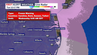

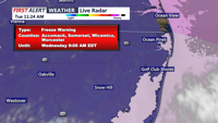

DELMARVA - Residents and visitors along the Delaware and Maryland coastline are urged to prepare for an unseasonable plunge in temperatures Tuesday night into early Wednesday. The National Weather Service has issued a Freeze Warning for southern Delaware and Maryland's coastal areas, including Ocean City, from 11 p.m. Tuesday through 9 a.m. Wednesday.
What to Expect
Winds will begin to die down late Tuesday as high pressure builds in, but the shift will come too late to prevent a significant temperature drop. Overnight lows are forecast to dip into the upper 20s and low 30s, with beach towns like Rehoboth Beach, Bethany Beach, Fenwick Island, and Ocean City not spared from the cold snap. This is particularly unusual, as the frost/freeze season doesn’t typically begin until April 11 in these regions.
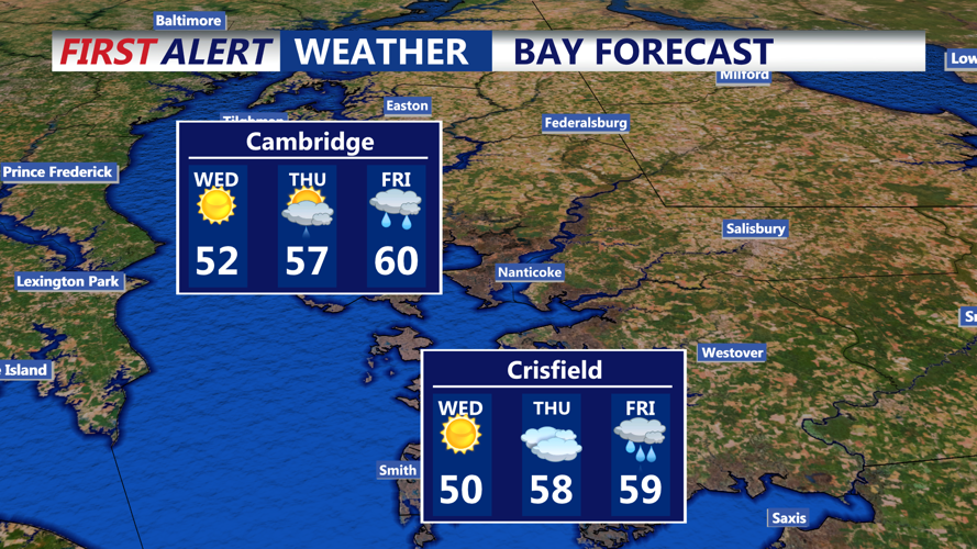
Although skies will remain mostly clear, the Canadian air mass overhead will bring the coldest air since 2018 for this time of year, with Wednesday highs only expected to reach the upper 40s to low 50s.
Precautions to Take
Protect Sensitive Plants: Bring potted plants indoors or cover outdoor vegetation with breathable materials.
Check Outdoor Plumbing: Ensure hoses are detached and exposed pipes are insulated to prevent freezing.
Animal Safety: Bring pets indoors or provide adequate shelter and bedding to keep them warm.
Heater Safety: If using space heaters, ensure they are placed away from flammable materials and never left unattended.
Looking Ahead
Conditions will gradually improve after sunrise Wednesday as high pressure begins to shift offshore by the evening, allowing temperatures to moderate slightly. However, Wednesday night will still be cold, with lows in the mid-30s for coastal areas.
Thursday brings cloudier skies and a slight chance of light showers west of the beaches, with temperatures climbing into the 50s. The end of the week looks wetter, as a developing low-pressure system could deliver significant rainfall by Friday night, with cooler-than-normal temperatures lingering into the weekend.
