


Sussex County and Delaware’s beach communities should expect a warm, humid start Wednesday, followed by an increasing chance of showers and thunderstorms later in the day and into the evening as a cold front moves through.
From
To


Today on Delmarva, a powerful storm system will bring the risk of strong to severe thunderstorms this afternoon into tonight, with damaging winds as the primary concern and an increasing threat for isolated tornadoes. Even outside of storms, southerly winds will gust from 35 to 45 mph, with some areas seeing gusts up to 50 mph. Heavy rainfall may lead to localized flash flooding, especially inland, while Sussex County faces minor coastal flooding along the back bays including Rehoboth Bay and Little Assawoman Bay. Conditions turn cooler and dry Tuesday through Wednesday before temperatures gradually moderate later in the week, with the next chance for showers arriving Friday night into Saturday.

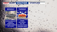
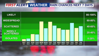
Starting Monday, Delmarva will enter a prolonged stretch of hot, humid, and stormy weather. The remnants of Tropical Storm Chantal will bring widespread showers and thunderstorms capable of downpours and localized flooding. Even the threat for severe storms Tuesday. As the week progresses, a stalled front and several disturbances will prolong unsettled conditions, with dangerous heat indices nearing 106 degrees and repeated rounds of storms expected into the weekend

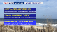
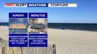
Beginning Sunday night, Delmarva will enter a period of high humidity and unsettled weather. The remnants of Tropical Storm Chantal will bring rounds of showers and thunderstorms Monday and Tuesday, with locally heavy rainfall and potential flash flooding. Severe storms possible Tuesday afternoon/evening. A stalled cold front will keep the region stormy through late week, while oppressive heat and humidity push heat index values to near 106 degrees.

Seasonably warm and increasingly humid conditions will build across Delmarva Sunday afternoon as high pressure shifts offshore. Highs will reach into the 80s to near 90, with an isolated thunderstorm possible by evening. By Monday and into midweek, a tropical air mass will set the stage for daily rounds of showers and thunderstorms. Some storms could produce heavy rainfall, localized flooding, and dangerous heat indices approaching 100 degrees inland.

High pressure offshore will usher in warmer and more humid air over Delmarva on Sunday, with highs climbing into the 80s to near 90 and muggy nights returning. While most areas should remain dry through Sunday, an isolated thunderstorm cannot be ruled out. By Monday and into the rest of the week, tropical moisture and unstable conditions will bring daily chances for showers and thunderstorms, some capable of heavy rainfall and localized flooding.


Pleasant weather will continue Saturday night across Delmarva, with partly cloudy skies and lows in the 60s. As high pressure shifts offshore, temperatures and humidity will climb Sunday into Monday. By early next week, a tropical and unsettled pattern will bring daily chances of showers and thunderstorms, heavy rainfall, and heat indices over 100 degrees.

High pressure will maintain calm and seasonable weather across Delmarva through the holiday weekend. Temperatures will climb into the upper 80s and low 90s by Sunday, with humidity gradually increasing. By early next week, a tropical, unsettled pattern is expected to develop, bringing daily chances for showers and thunderstorms along with oppressive heat and potential localized flooding.

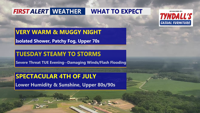
Monday brought another round of oppressive heat and intense downpours across parts of Delmarva, including Long Neck and Ocean View, where up to four inches of rain fell in just an hour. A cold front is forecast to move through the region late Tuesday, gradually lowering humidity levels by midweek. High pressure building into the area should bring drier and more comfortable weather heading into the Fourth of July weekend.

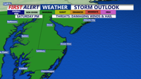
Showers and possible thunderstorms Saturday afternoon and evening, with the chance for strong wind gusts, hail and localized flooding. Conditions improve by Sunday, ushering in a stretch of dry and warmer weather through midweek, with summer-like temperatures returning by Wednesday.