


DELMARVA -- A sticky start to the workweek as high pressure retreats offshore Sunday night. With a Bermuda High settling in, humidity will surge, and temperatures will stay warm overnight, only dipping into the mid to upper 70s. Low clouds and areas of light fog are likely to develop before dawn, with a stray shower possible. Light southerly to southeasterly winds are expected.

Remnants of Chantal move in Monday, cold front Tuesday stalls out bring on and off showers and storms through the week.
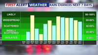
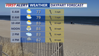
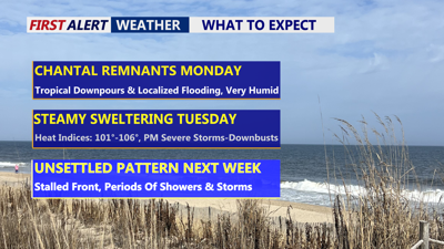
On Monday, the lingering moisture from the remnants of Tropical Storm Chantal will combine with upper-level disturbances to generate widespread showers and scattered thunderstorms across Delmarva. Highs will be in the mid to upper 80s, few 90s are possible prior to any storms.

Warm and very muggy, scattered tropical downpours, some gusty winds.
Downpours may be intense enough to trigger localized flooding, especially in low-lying areas and poor drainage spots. Rainfall totals could exceed two inches in isolated spots, though most of the region is expected to see between one and two inches, with locally higher totals in spots where heaviest storms track.

Remnants of Chantal pass over the peninsula Monday bringing scattered gusty downpours.
In addition to heavy rain, a few storms could become strong or severe, producing gusty winds.
Temperatures will be slightly cooler than previous days, but high dew points will keep conditions uncomfortable.
As a cold front begins to slowly sink southward Monday night into Tuesday, the stage will be set for more showers and thunderstorms. On Tuesday, the front will stall over the southern Delmarva Peninsula, acting as a trigger for additional convection.
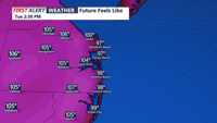
The combination of daytime heating, tropical moisture, and the stalled front will create an environment ripe for heavy rain and potentially severe storms. Temperatures are forecast to soar into the mid-90s, with dew points deep in the 70s. This oppressive combination will push heat index values to between 100 and 106 degrees, creating dangerous conditions for anyone working or spending extended time outdoors.

Tuesday afternoon feeling like 100-106 ahead of a cold front.
Damaging wind gusts from severe thunderstorms are possible, and localized flash flooding remains a concern due to the potential for training storms. The region has been placed under a Marginal Risk for both severe weather and excessive rainfall.
The unsettled weather pattern won’t end quickly. The stalled front will remain draped across Delmarva into midweek, with isolated to scattered showers and storms persisting Wednesday. Another weak disturbance is expected to pass through Thursday and Friday, prolonging the chance for daily showers and thunderstorms. Yet another system could arrive Saturday, maintaining the wet pattern.