


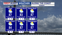

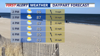


DELMARVA -- Sunday afternoon will mark the start of a gradual change across Delmarva as high pressure drifts offshore and return flow begins to draw warmer, more humid air into the region. Temperatures will rise into the upper 80s to low 90s under partly sunny skies, and humidity will steadily increase throughout the day.

Warm and muggy Sunday, an isolated t-storm is possible, highs 80s to near 90.
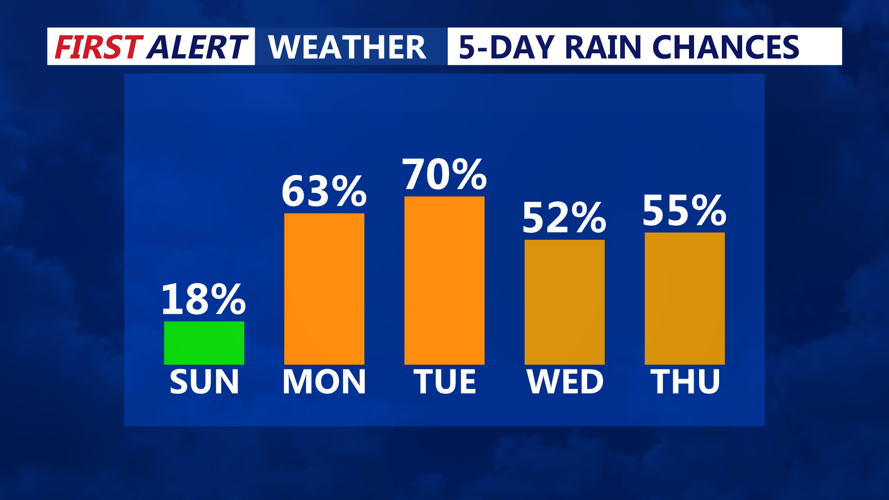
While much of Sunday should remain dry, a weakening tropical disturbance lingering over the Carolinas will send some moisture northward. This may be just enough to trigger an isolated thunderstorm during the late afternoon or evening, though widespread rainfall is not expected.
Sunday night will feel distinctly more humid than recent nights. Temperatures will hold in the low to mid-70s, and patchy fog could develop in spots as dewpoints continue to climb.

Turning unsettled Monday with tropical downpours, front stalls over the area Tuesday with scattered showers and storms.
By Monday, conditions will become noticeably tropical and unstable. An upper jet streak to the northeast will create weak diffluence aloft, combining with daytime heating and rich moisture to fuel scattered showers and thunderstorms by midday. Although the environment is not expected to support widespread severe storms, a few stronger cells could develop. These may bring gusty winds, locally heavy rainfall, and the potential for minor flooding in areas prone to poor drainage.
Highs Monday afternoon will once again reach the upper 80s to low 90s, but higher dewpoints will create heat indices in the mid to upper 90s, especially for inland communities. Cloud cover will also increase, and warm, muggy conditions will persist overnight, with lows staying in the 70s.
The unsettled pattern will hold through much of the upcoming week.
From Tuesday through Friday, daily chances for showers and thunderstorms will continue. Tuesday in particular looks to bring the greatest coverage of storms as a shortwave trough crosses the region from the Great Lakes. The atmosphere will be primed with abundant tropical moisture. Storms may develop repeatedly over the same areas, increasing the risk of localized flooding.

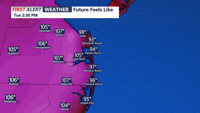
Heat indices Tuesday afternoon could approach 100-106 ahead of a cold front.
Temperatures will remain near to slightly above normal throughout the period. Highs are forecast to range from the mid-80s to low 90s, and overnight lows will be warm and humid, generally in the mid-60s to mid-70s. On Tuesday, heat indices could reach above 100 degrees in the southern half of the area, although cloud cover and occasional storms could help keep the heat in check at times.
Wednesday is expected to bring a temporary lull in activity, with fewer storms as the system moves offshore. However, another disturbance approaching by Thursday or Friday will likely reintroduce a higher chance for showers and storms to end the workweek.
