


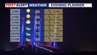


DELMARVA -- The rest of your Saturday afternoon will feature dry and tranquil conditions on Delmarva as high pressure remains firmly in control. Seasonable temperatures and light winds will make for a pleasant holiday weekend, with highs generally in the mid to upper 80s.

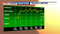
Warm and slightly muggy night as humidity increases, could see patchy fog late.
Saturday night will stay comfortable under partly cloudy skies, with lows dipping into the mid to upper 60s. Humidity will begin creeping upward overnight, and a few patches of fog may develop toward dawn.

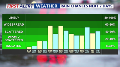
Tropical-like airmass moves in to start the new week.
Sunday will bring a noticeable uptick in warmth and moisture as high pressure shifts offshore and return flow begins to establish itself over the region. High temperatures are forecast to climb into the upper 80s to near 90 degrees, with dewpoints rising into the upper 60s and low 70s. Most areas should stay dry, but an isolated afternoon thunderstorm can’t be ruled out as the weakening remnants of a Tropical Storm Chantal over the Carolinas brush past the area. Sunday night will turn warm and muggy, with lows holding near 70 to 75 degrees.

Tropical Storm Chantal slowly churning off the South Carolina coast will tap into some moisture from this system Monday.
By Monday, the atmosphere will take on a decidedly tropical character. Increasing humidity, daytime heating, and a weak upper-level disturbance will combine to spark scattered showers and thunderstorms starting around midday. While severe weather is not expected to be widespread, a few storms could become strong with gusty winds and locally heavy downpours. Temperatures will remain in the upper 80s to low 90s, but higher dewpoints will drive heat indices into the mid to upper 90s inland.
Looking ahead to Tuesday and beyond, unsettled weather is forecast to linger across Delmarva. A series of disturbances approaching from the Midwest will maintain daily chances for showers and thunderstorms through the end of the week. Tuesday may bring the greatest storm coverage and a heightened threat of localized flooding due to tropical moisture pooling over the region. Heat and humidity will remain oppressive at times, with daytime highs in the mid-80s to around 90 and warm, muggy nights.