


DELMARVA -- Saturday night will feature comfortable conditions across Delmarva under partly cloudy skies. Temperatures will fall into the mid to upper 60s, but humidity will gradually begin to rise overnight. A few patches of fog may develop toward daybreak Sunday.
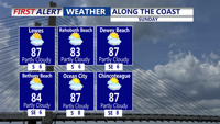
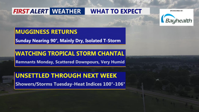
Sunday will mark the start of a gradual transition to warmer and more humid weather as high pressure moves offshore. Highs are expected to reach the upper 80s to low 90s across much of the region. With dewpoints increasing into the upper 60s and low 70s, the day will feel noticeably more muggy than recent afternoons.

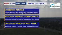
Partly cloudy skies, uptick in humidity, isolated t-storm possible.
Most of Sunday should remain dry, but the weakening remnants of a tropical cyclone Chantal drifting across the Carolinas could trigger an isolated thunderstorm in the late afternoon or evening. Sunday night will stay warm and humid, with lows holding in the 70 to 75 degree range.

Unsettled week ahead, turns very tropical with daily shower and t-storm chances, we tap into some moisture form Tropical Storm Chantal Monday.
By Monday, the atmosphere will become decidedly tropical. A combination of rising moisture and daytime heating is forecast to spark scattered showers and thunderstorms beginning around midday. While severe weather is not expected to be widespread, a few stronger storms could produce gusty winds, locally heavy rain, and brief flooding. Highs will again reach the upper 80s to low 90s, but humidity will be even higher than Sunday, pushing heat indices into the mid to upper 90s inland. Nighttime conditions will remain very warm and muggy, with lows in the low to mid-70s and little relief from the humidity.
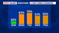
The unsettled pattern is expected to persist through much of the coming week. Daily chances for showers and thunderstorms will continue from Tuesday through at least Friday as several disturbances track across the region. Tuesday will likely bring the most widespread storms and the greatest threat for heavy rainfall and localized flooding. The environment will remain very moist, with potential for training downpours in any stronger cells.
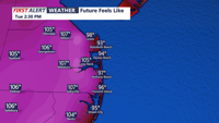
Temperatures through the week will run near or slightly above seasonal averages. Highs will generally range from the mid-80s to low 90s, with heat indices possibly approaching over 100 degrees at times, especially on Tuesday.

Could see some triple digit heat indices on Delmarva Tuesday afternoon.
Lows will stay warm in the mid-60s to mid-70s each night. By late week, onshore flow developing behind the next system may help moderate temperatures slightly, but warm and humid conditions are forecast to linger.
