


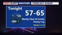
Delmarva begins the week with patchy morning fog Monday, followed by sunny skies and highs in the mid to upper 80s. Temperatures climb into the upper 80s and low 90s by Tuesday and Wednesday, with increasing humidity. A cold front is expected late week, bringing only a slight chance for showers or storms before warm, mostly dry conditions return for the weekend.
From
To

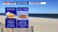
Delmarva wraps up a picture-perfect weekend with another cool, clear night Sunday, before temperatures rise into the upper 80s and low 90s by midweek. Patchy fog is possible Monday morning, followed by mostly sunny skies. A cold front is expected late week, bringing slightly lower humidity and a slim chance for showers or storms.

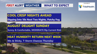
Unseasonably cool weather will stick around through the weekend, with sunny skies and below-average temperatures continuing Sunday. Overnight lows will dip into the 50s inland and 60s at the coast, with a moderate rip current risk from Delaware beaches to Chincoteague. A gradual warm-up begins early next week, leading into hotter and more humid conditions by midweek, with a chance of storms Wednesday and Thursday.

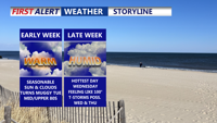
Delmarva will enjoy a stretch of sunny, comfortable weather from Saturday through Monday, with only light breezes and mild temperatures. However a HIGH risk of rip currents remains for all beach points in Delaware, to Ocean City to Chincoteague. Conditions will heat up by midweek, with highs in the 90s, rising humidity, and a chance for scattered afternoon storms.


Delmarva will enjoy clear skies and comfortable temperatures Friday night through the weekend as high pressure lingers over the region. Temperatures will gradually warm into early next week, with highs nearing the 90s by midweek as humidity increases and scattered storms become possible.

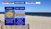
Sunday brings a refreshing start to June on Delmarva, with dry conditions, cool temperatures, and a light breeze. High pressure will dominate the region through midweek, setting the stage for a warming trend that could bring the first 90-degree day of the year by Thursday.