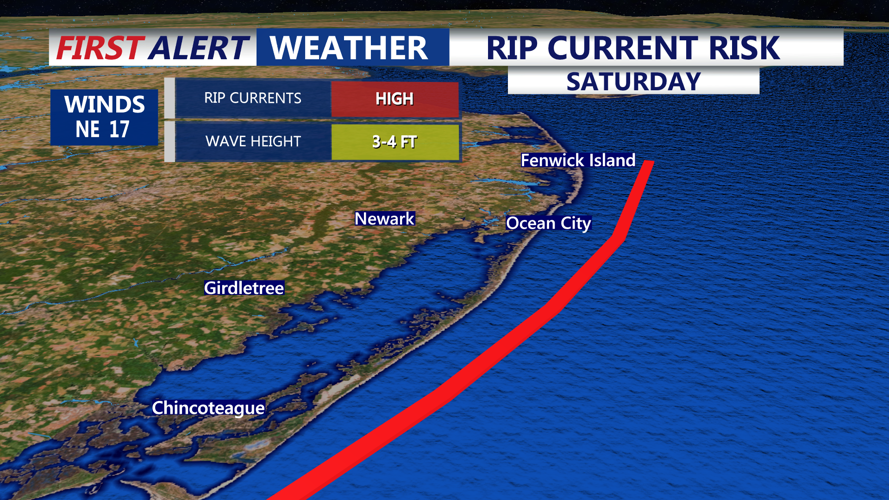
DELMARVA -- The threat of dangerous rip currents will continue along the DE Beaches, Ocean City to Assateague Island and Chincoteague.
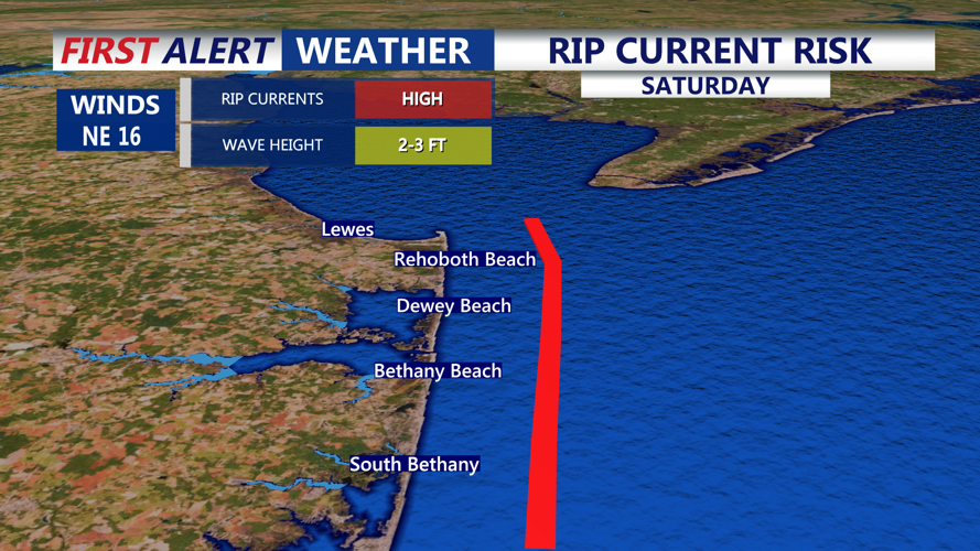
Dangerous threat of rip currents persists into the weekend for all the DE Beaches.
All thanks to persistent onshore flow, full moon and an area of low pressure out in the Atlantic. Remember to always swim near lifeguards and obey there commands.
HIGH risk of rip currents continue from Ocean City down to Chincoteague, use caution and always swim near lifeguards.
Mostly clear skies and calming winds will set the stage for a pleasant overnight across Delmarva. Winds will ease and shift slightly to the north-northeast as high pressure moves over the region. Ideal radiational cooling will drop overnight lows into the low to mid-60s.
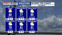
Highs on Saturday in the upper 70s to low 80s at the coast under partly cloudy skies, northeast winds 10-20. Dangerous risk of rip currents.
High pressure, initially anchored over the Mid-Atlantic and New England, will shift slowly eastward through the weekend, keeping the weather calm and dry. Saturday will bring mostly sunny skies inland with highs in the low 80s and light winds of 5 to 10 mph. Along the coasts of Delaware and New Jersey, some clouds may redevelop in the afternoon, with slightly stronger winds and gusts up to 20 mph possible. Coastal highs will hold in the upper 70s.
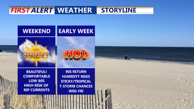
Saturday night will be cool and comfortable, with lows ranging from the mid-50s to near 60 degrees under clear skies. Sunday and Monday will feature abundant sunshine, light winds, and a modest warm-up. Highs will reach the low to mid-80s, with the urban corridor potentially nearing 90 degrees. Overnight lows will climb into the low to mid-60s.
By Tuesday, the ridge of high pressure will begin to weaken and shift farther offshore. Temperatures will rise, with highs reaching the mid-80s to near 90 Tuesday, and climbing into the low to mid-90s Wednesday and Thursday. Humidity will increase midweek, with dewpoints in the low to mid-70s, creating more muggy conditions.
While the pattern is not favorable for widespread storms, isolated to widely scattered afternoon and evening showers or thunderstorms will be possible from Wednesday through Friday. Highs will drop back into the 80s by the end of the week as the unsettled pattern continues.
Paul Williams has earned ASSOCIATED PRESS CHESAPEAKE BAY
BEST WEATHER ANCHOR/METEOROLOLOGIST 2019, 2021, 2023, and serves as
the chief meteorologist at CoastTV, delivering weather forecasts
during the 5, 6, and 11 p.m. broadcasts. As a key member of the
Draper Media storm tracker weather team, he provides crucial
emergency weather information to help safeguard the
community.
Chris Mastrobuono is a South Philly native, but has come to join
the CoastTV meteorology team. With over three years of experience
delivering accurate, passionate and insightful weather analysis, he
is eager to report on the coast. Previously, he spent over two
years as a morning meteorologist at WEVV CBS/FOX in Evansville,
Indiana.