


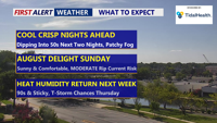


DELMARVA -- Saturday night will continue the streak of below-average temperatures that has defined the start of August, with the region running cooler than the normal high of 87 degrees. Under clear skies, temperatures will fall into the 50s inland and the 60s along the coast. A few spots could see patchy fog develop by morning, especially in low-lying areas.

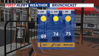
Starting the day in the 50s for some, sunny skies and comfortable as you make your way to brunch.
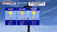
Sunday promises another picture-perfect summer day, with highs in the upper 70s to low 80s — well below seasonal norms — and plenty of sunshine.

Wall-to-wall sunshine for our Sunday, highs remaining below average.
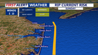
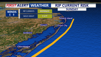
However, beachgoers should remain cautious, as a moderate risk of rip currents is in place from Delaware beaches south through Ocean City and Chincoteague. Officials advise swimmers to stay near lifeguards.

MODERATE rip current threat for the DE Beaches on Sunday.

MODERATE rip current risk Sunday from Ocean City to Chincoteague.
Sunday night will again bring cool conditions, with inland lows dipping into the 50s and coastal areas holding in the 60s. High pressure over the region will gradually weaken and slide east early next week, ushering in a warmer pattern.
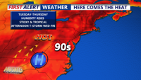
By Monday and Tuesday, a shortwave ridge over the Northeast will help boost temperatures into the upper 80s to near 90, dew points will slowly rise into the 70s. The warm, calm conditions could still lead to some patchy fog late Monday night into Tuesday morning.
Midweek brings a shift in the pattern. A surface trough is forecast to develop across the area Wednesday, combining with an unstable air mass to spark scattered showers and thunderstorms, especially inland during the afternoon and evening. Highs will push into the low 90s, with dew points in the low 70s driving heat indices close to 100 degrees for many locations away from the coast.

High pressure slides to our south opening the door for the return of heat and humidity by midweek.
On Thursday, a cold front will approach from the northwest, bringing additional storm chances. While cloud cover and precipitation may temper temperatures slightly, humidity will remain high.
By Friday and Saturday, the cold front may stall near the region as mid-level ridging builds in from the south. High pressure to the north could nudge slightly cooler air into the area, but the positioning of the front will determine whether the end of the week remains unsettled with lingering storm chances.