


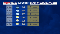
Watch for areas of fog early Sunday, then much warmer, with 70s later in the day.
From
To

A beautiful end to the weekend, then cooler with showers into next week.

Low pressure slides to our south later today into early Monday morning bringing a soaking rain.

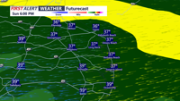
Low pressure slides to our south late Sunday into early Monday morning bringing a soaking rain.

More clouds than sun this weekend and chilly. Then much colder early next week.


As smoke from Canadian wildfires rotates across the Delmarva Peninsula, people remain vigilant and air keeping their on the air quality. DNREC says air quality is moderate which means there may be a risk for some people, particularly those who are unusually sensitive to air pollution.

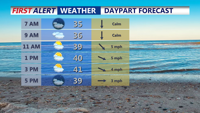
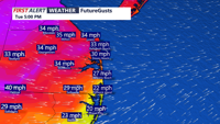
Occasional showers continue this afternoon, with an onshore flow keeping temperatures cooler with highs mainly in the 60s. Some low 70s are possible at some inland spots this afternoon. Winds will gust up to 20 mph at times from the southeast, making it feel a bit cooler.


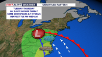
High pressure will maintain relatively quiet and comfortable weather across the Delmarva Peninsula through Monday, but change is coming. A prolonged stretch of unsettled weather is set to move in beginning Monday night, with several rounds of showers and thunderstorms expected through the weekend.

We've seen a round of showers and storms to start our Friday, with more on the way this afternoon and possibly this evening. Highs in the 60s, and possibly 70s where the sun is out a bit longer.

DELMARVA- A few scattered showers may linger early this afternoon, especially near the coast. Gusty northwest winds will develop this afternoo…