


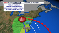


DELMARVA- Occasional showers continue this afternoon, with an onshore flow keeping temperatures cooler with highs mainly in the 60s. Some low 70s are possible at some inland spots this afternoon. Winds will gust up to 20 mph at times from the southeast, making it feel a bit cooler.
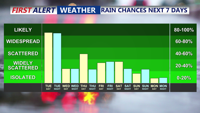
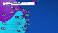
Expect showers to be more widespread through Tuesday night and linger into Wednesday. While the rain will be generally light, periods of moderate to heavy showers may occur. Rainfall totals from Monday night through Wednesday are expected to reach between a half inch to an inch, with locally higher amounts possible. The threat for severe weather is minimal. Overnight lows will remain relatively warm and muggy in the 60s.
For Wednesday we could see a lull in activity for a good part of the days, with isolated to scattered showers expected from time to time. Highs will be in the 70s, with some cooler 60s at the beaches.
By Wednesday night, the low-pressure system begins to weaken and transition into a shortwave trough. Rain chances persist into Thursday, especially in the afternoon, when showers may become scattered again. Highs on Thursday are forecast to reach the 70s to near 80, with lows remaining mild in the low to mid 60s.
A temporary break in the rain is possible from Thursday night into Friday morning, as weak high pressure builds over the region. However, this reprieve will be short-lived. Another low-pressure system from the Great Lakes will drive cold fronts through Delmarva late Friday and again on Saturday.
These fronts will bring warmer temperatures, highs reaching into the 80s both days, as well as higher humidity, but also increase the chances for stronger thunderstorms. With more atmospheric instability expected by the weekend, we will monitor the potential for severe weather, though current signals do not indicate widespread threats.
