


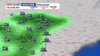
We're locked into a cold pattern across Delmarva for the rest of the week. Temperatures do warm gradually for the week ahead, then drop again by Friday into the weekend. Some rain and lots of wind for Thursday, and possible snowflakes.
From
To

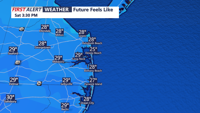
A cold and blustery Saturday kicks off the weekend on Delmarva, with highs barely reaching 40 degrees and wind chills staying in the 20s. High pressure ensures dry conditions through Saturday night, but a weak disturbance Sunday night may bring rain or snow showers to the region. A stronger system midweek could deliver possibly snow showers midweek.

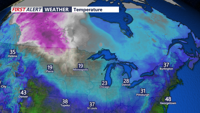
A cold front will clear the Delmarva region tonight, ushering in the coldest air mass of the season. Temperatures are expected to drop into the mid to upper 20s, with wind chills falling well below freezing. High pressure will bring dry but chilly conditions for Saturday, with wind chills making it feel like the 20s. A weak disturbance Sunday night could bring light snow or mixed precipitation to parts of the region.

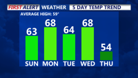
Delmarva will enjoy sunny skies and seasonable temperatures through the early part of the week, with high pressure dominating the weather pattern. Changes arrive midweek as a frontal system brings rain and possibly a few thunderstorms by Wednesday night into Thursday. Cooler and unsettled weather will follow through the end of the week.

Sussex County’s beach towns will experience cooler temperatures, some cloud cover, and isolated chances of frost overnight Monday, with mostly dry conditions and occasional cloudiness through Tuesday.


High pressure will dominate our weather through early next week, bringing sunny skies and comfortable temperatures across the Delmarva Peninsula.