


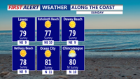
A nice end to the weekend, then increasing storm chances next week.
From
To

A breath of fresh air continues across Delmarva, with noticeably lower humidity, cooler temperatures, and plenty of sunshine today.

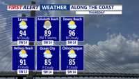
Today will turn hotter and more humid across Delmarva. Skies will be partly sunny, with highs climbing into the low 90s for many inland locations.

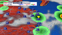
A cold front will sweep through on Sunday, helping to break the heat.

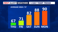
Delmarva will dry out this afternoon after morning showers, but rainfall totals were too light to make a meaningful dent in the ongoing severe drought. Breezy northwest winds and highs in the 60s will give way to a pleasant Friday, followed by a warmer, mostly dry weekend. By early next week, temperatures could climb into the upper 80s and low 90s before a cold front brings the next chance for storms around the middle of next week.


It's a much cooler start on our Monday morning, with temperatures in the 50s under cloudy skies.

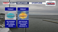
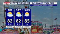
Delmarva saw light rainfall overnight into this morning, but totals were not enough to make a major dent in dry conditions. Skies will gradually clear later today with temperatures in the 50s and 60s. Friday looks bright and breezy, followed by a warmer Mother’s Day weekend with shower and thunderstorm chances returning Saturday and again Sunday night into Monday.

The chilly rain this afternoon will taper off late afternoon or early evening. Up to a quarter inch of rain is possible in some areas. Temperatures will be in the 40s and 50s.


Conditions are looking dry, breezy, and mild for Sunrise services Easter Sunday morning.


Near record warmth this afternoon, Easter Sunday becomes rainy with storms possible.