


Rain and drizzle fade late tonight, then linger into Friday morning before a mostly cloudy, milder finish to the day.
From
To

Patchy freezing drizzle or a brief wintry mix early Wednesday may create isolated slick spots, followed by a colder stretch with a renewed refreeze risk Wednesday night into early Thursday.

Rain changes to snow later this afternoon and evening with light accumulations, then bitterly cold air follows into early next week.

Rain changes to snow later today with light accumulations, then bitterly cold air follows into early next week.

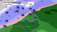
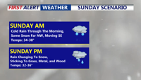
Rain changes to snow Sunday with light accumulations, then bitterly cold air follows into early next week.

More clouds than sun today and a bit milder, then windy and warmer start to week.

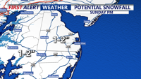
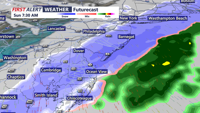
Snow is expected to develop early Sunday morning and continue through late Sunday morning. Accumulations are expected to be in the 1-3" range, with slick roads Sunday morning.

Snow is expected to develop early Sunday morning and continue through late Sunday morning. Accumulations are expected to be in the 1-3" range, with slick roads Sunday morning.

Watch for dense fog in spots this morning, causing slick roads and bridge decks, with temperatures into the 20s to near 30.

Areas of dense fog overnight, then more clouds than sun for Sunday and chilly. Then much colder early next week.