


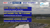
A surface trough will move through Delmarva Wednesday night, bringing scattered showers and thunderstorms, some with heavy rainfall possible. While the risk of severe weather is low, lingering storms and patchy fog are possible overnight. The unsettled pattern continues into Thursday before improving conditions arrive by the weekend.
From
To

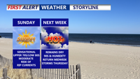
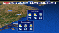
Delmarva will enjoy a sunny and comfortable Sunday, with highs in the upper 70s to low 80s and a moderate rip current risk from Delaware beaches through Chincoteague. Overnight lows will dip into the 50s inland and 60s at the coast. High pressure will weaken early next week, bringing a warming trend into the upper 80s and low 90s by Tuesday. Midweek turns hotter and more humid, with a surface trough and cold front increasing the chances for showers and storms Wednesday and Thursday. The front may stall into the weekend, keeping the forecast unsettled.

Delmarva will enjoy another sunny and comfortable day on Sunday, with highs in the upper 70s to low 80s — several degrees below normal for early August. A moderate rip current risk will remain in effect for Delaware beaches through Chincoteague, and swimmers are urged to stay near lifeguards. Overnight lows will dip into the 50s inland and 60s near the coast. High pressure will weaken early in the week, bringing a warming trend that pushes highs into the upper 80s to low 90s by Tuesday. Midweek turns hotter and more humid.

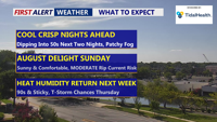
Unseasonably cool weather will stick around through the weekend, with sunny skies and below-average temperatures continuing Sunday. Overnight lows will dip into the 50s inland and 60s at the coast, with a moderate rip current risk from Delaware beaches to Chincoteague. A gradual warm-up begins early next week, leading into hotter and more humid conditions by midweek, with a chance of storms Wednesday and Thursday.

Delmarva enters a stretch of mild, mostly dry weather beginning Wednesday night, thanks to high pressure settling to the north and northeast. Although a weak coastal low may trigger a few isolated showers later this week, most areas will remain dry with gradually warming temperatures. Humidity will increase early next week, bringing hot conditions and a slight chance of showers and storms.

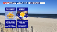
The Delmarva region will experience above-normal temperatures and isolated thunderstorms on Thursday, followed by a stronger weather system moving in late Friday through the weekend.

Wednesday brings scattered showers and thunderstorms to Delmarva as a shortwave trough passes through, while temperatures climb into the 90s. The trend towards drier and hotter weather continues into the weekend, with potential heat advisories.