


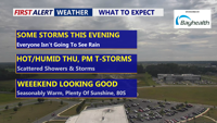


DELMARVA -- Wednesday night will bring unsettled weather to Delmarva as a surface trough slowly moves across the region, followed by a cold front from the northwest Thursday. While there is some potential this evening for strong to severe thunderstorms, the risk is low due to weak wind shear. Any storms that do form will likely be short-lived but capable of producing heavy downpours.
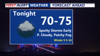
Showers and thunderstorms are expected to taper off by midnight, though the front may stall over parts of the Mid-Atlantic, keeping a chance for lingering showers and storms in the area. Patchy fog may develop overnight, especially where skies clear and winds remain light. Lows will generally be in the low 70s.

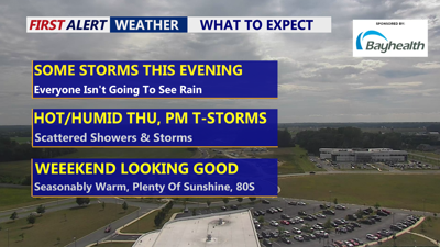
Few showers and storms early, otherwise partly cloudy with patchy fog, muggy low 70s.
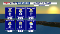
On Thursday, the upper trough and surface front will remain in the area, bringing scattered morning showers and mostly cloudy skies.

Partly sunny, warm and humid, scattered showers and downpours develop afternoon-evening.
Afternoon heating could spark additional thunderstorms, but severe weather is not expected. Locally heavy rain is possible, with flash flooding a possibility. Highs will range from 85 to 92 degrees.

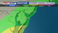
Marginal risk of excessive rainfall Thursday, some storms could lead to localized flash flooding.
By Thursday night, the front is forecast to settle south of the region, with any remaining showers dissipating. Slightly drier air may filter in from the north Friday, lowering humidity levels in northern areas. Highs Friday will be in the mid 80s. High pressure will begin to build in through Saturday, allowing for more sunshine and seasonably warm temperatures. The weekend looks really good, highs in the mid to upper 80s.
Looking ahead, the warm and humid pattern continues into Sunday, when another cold front is expected to move through late in the day. High pressure will return early next week, bringing cooler and less humid conditions by Wednesday.