


DELMARVA -- Wednesday night marks the beginning of a stable weather pattern across the Delmarva Peninsula, as high pressure anchored well to the north builds and drifts northeastward through the weekend. The result is a largely dry and pleasant stretch of days, with only a few chances of isolated showers.
Skies Wednesday night are expected to remain mostly cloudy to overcast, with some haze lingering in areas free of cloud cover or showers. Overnight lows will drop into the 60s for most locations.
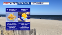
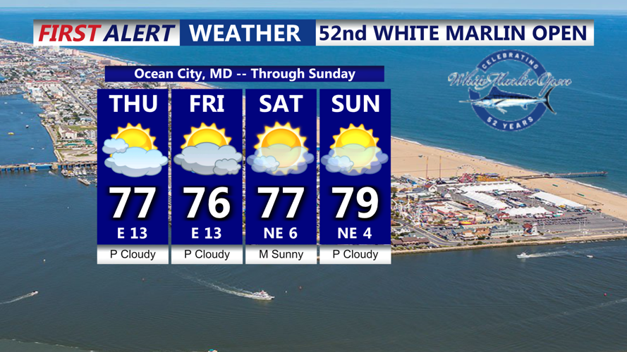
Thursday will bring sunnier skies, especially by midday, as drier air settles into the region. While a weak area of low pressure may try to develop offshore to the south, any resulting showers will be isolated. Most of Delmarva should stay dry, with high temperatures ranging from the upper 70s to mid-80s.

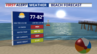
Partly cloudy skies, highs in the upper 70s to low 80s, east wind continues 10-20, HIGH rip current risk Thursday. Swim near lifeguards.
Keep in mind we have a HIGH risk of rip currents for the DE Beaches, Ocean City to Assateague Island. 2-3 ft waves, make sure to swim near lifeguards and obey there directions.

Partly cloudy skies Thursday, chance of showers Friday, weekend looks very nice but gusty off the coast.
The influence of high pressure becomes more pronounced Thursday night into Friday, tightening the pressure gradient as weak low pressure remains well to the south. With lower dewpoints and clearer skies inland, overnight lows could dip into the mid-50s to low 60s, while coastal areas hold steady in the mid-60s to near 70 degrees.

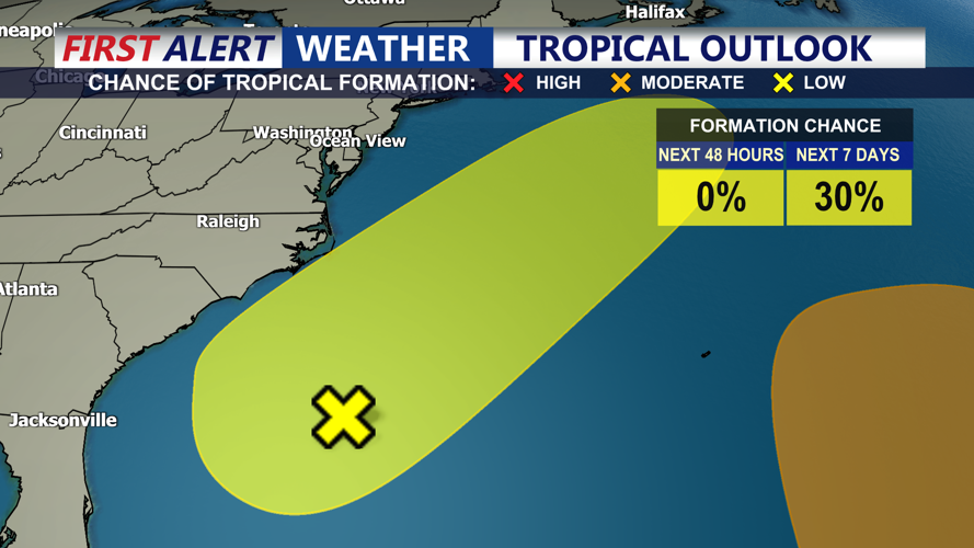
Low pressure off the southeast coast has a 30% chance of development, system is expected to move away from the coast through the weekend.
Friday’s forecast calls for a mix of sun and clouds. Highs will range from the upper 70s to low 80s, although southern portions of the peninsula may see more cloud cover and perhaps a passing shower due to onshore flow from the southeast coast.
The weekend continues the trend of fair weather. A developing upper-level ridge will help reinforce dry conditions across the region. Saturday temperatures will remain seasonal to slightly below average, with continued low humidity.
By Sunday and into early next week, the ridge aloft and high pressure at the surface will shift eastward, allowing warmer and more humid air to flow in from the south. Temperatures will climb into the upper 80s to around 90 degrees on Sunday and Monday. By Tuesday and Wednesday, many locations across Delmarva could see highs in the low to mid-90s.
With the heat and moisture building, there will be a 20 to 40 percent chance for afternoon showers or thunderstorms by midweek. However, confidence in any widespread activity remains low, pending the development of a surface trough or cold front.


