


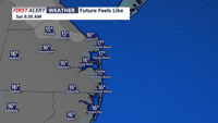
Low clouds and patchy fog linger late Friday as small-craft conditions continue offshore, then Saturday turns calmer and milder — a short window to get ready for a wintry, windy system set to arrive Sunday into Monday.
From
To

Mostly sunny skies today will give way to a burst of dangerous arctic cold Friday night, then a high-impact winter storm threat Saturday night through early Monday, followed by days of bitter cold.


Light rain late Wednesday evening may briefly mix with snow early Thursday before temperatures fall and gusty winds usher in colder air.

Sussex County will experience a range of weather conditions from Tuesday through Thursday, including mild temperatures, a cold front passage, and a mix of precipitation types.

Sussex County will experience mild and dry weather through Tuesday, with a cold front bringing cooler temperatures by Tuesday night. A low-pressure system is anticipated to affect the area midweek, introducing a mix of precipitation types.

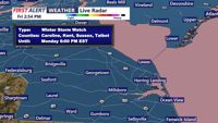
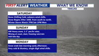
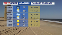
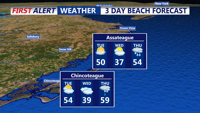
Bitter cold conditions will grip Sussex County through Saturday night and Sunday, with lows in the teens and highs struggling to reach the mid-30s. Forecasters are monitoring a potential snowstorm expected to impact the area late Sunday night into Monday.