site-logo
Facebook Instagram Threads X LinkedIn YouTube LinkedIn
  • Sign Up
  • Log In
  • Dashboard
  • Logout
    • My Account
    • Dashboard
    • Profile
    • Saved items
    • Logout
Home
  • About Us
  • Contact Us
  • Programming
  • Our Team
  • Submit a Tip
  • Newsletters
  • Apps
CoastTV Poll
News
  • Local News
  • Regional News
  • National News
  • International News
  • Feel Good
  • Police and Fire
  • Education
  • Politics
  • Business
  • Area Development
  • Environment
  • Health
  • Roadwork
  • Things to Do
  • Latest Newscasts
  • Featured Videos
Weather
  • Latest Forecast
  • Weather Cameras
  • Closings
  • Phone
  • Weather101
Traffic
Features
  • Cool Things
  • Coastal Connections
  • The Ties That Bind Us
  • Week in Review
  • Seaside Guides
  • Pet of the Day
  • Petey the Peacock
  • Salutes
  • Soaring Over the Shore
  • Umbrella Giveaway
  • Photo Booth
  • Lewes Fire Controversy
Delmarva Sports Network
CoastLife
Radio
  • Coast Country 103.9 & 106.3
  • 93.5 The Beach
  • BIG 107.7
  • 102.5 WBOC
  • 107.1 The Duck
  • 100.9% Classic Country
  • Watch Live
  • Apps
  • Contact Us
  • My Account
  • Sign Up
  • Log In
  • Dashboard
  • Logout
    • My Account
    • Dashboard
    • Profile
    • Saved items
    • Logout
Facebook Instagram Threads X LinkedIn YouTube LinkedIn
  • 55° Cloudy
    • Milton, DE (19968)

      Today

      Periods of rain. Becoming windy late. Low 54F. Winds E at 20 to 30 mph. Chance of rain 70%. Rainfall near a quarter of an inch. Locally heavy rainfall possible..

      Tonight

      Periods of rain. Becoming windy late. Low 54F. Winds E at 20 to 30 mph. Chance of rain 70%. Rainfall near a quarter of an inch. Locally heavy rainfall possible.

      Updated: October 29, 2025 @ 5:32 pm

    • Full Forecast
site-logo
Wednesday, October 29, 2025
Watch Live

Newscast Schedule

View Programming Schedule
site-logo
  • 55°
  • Home
  • News
    • Local News
    • Regional News
    • National News
    • International News
    • Feel Good
    • Police and Fire
    • Education
    • Politics
    • Business
    • Tariffs
    • Area Development
    • Roadwork
    • Environment
    • Health
    • Things to Do
    • Latest Newscasts
    • Video
  • Weather
    • Weather Cameras
    • Umbrellas
    • Closings
    • Weather Phone
    • Weather101
  • Traffic
  • Delmarva Sports Network
  • CoastLife
  • Features
    • Cool Things to Do
    • Coastal Connections
    • The Ties That Bind Us
    • Week in Review
    • Seaside Guides
    • Pet of the Day
    • Petey the Peacock
    • Salutes
    • Umbrella Giveaway
    • Photo Booth
    • Soaring Over the Shore
    • Lewes Fire Controversy
  • Poll
  • About Us
    • About CoastTV
    • Bios
    • Contact Us
    • Newsletters
    • Apps
    • Channel Finder
    • Careers
    • Internships
  • Submit a tip
Broadcast Schedule

On air schedule

Weather Alert

Weather Alert

...COASTAL FLOOD ADVISORY REMAINS IN EFFECT UNTIL 8 PM EDT
THURSDAY...

* WHAT...Up to one foot of inundation above ground level in low-
lying areas near shorelines and tidal waterways.

* WHERE...In Delaware, Inland Sussex and Delaware Beaches. In
New Jersey, Cape May and Atlantic Coastal Cape May.

* WHEN...Until 8 PM EDT Thursday.

* IMPACTS...At this level, flooding begins on the most
vulnerable roads in coastal and bayside communities, and along
inland tidal waterways. Some partial or full road closures are
possible.

* ADDITIONAL DETAILS...Spotty moderate flooding is possible in the
back bays of Rehoboth Bay, Indian River Bay, and Little
Assawoman Bay in Delaware with this evening's high tide cycle.

PRECAUTIONARY/PREPAREDNESS ACTIONS...

A Coastal Flood Advisory means that minor tidal flooding is
expected. Minor tidal flooding often results in some road
closures. Usually, the most vulnerable roadways will flood.

Do not leave your vehicle at a location that is prone to tidal
flooding. Do not drive your vehicle through flood waters. The
water may be deeper than you think it is. You will be putting
yourself in danger and your vehicle may be damaged, leading to
costly repairs.

Visit the National Water Prediction Service at
https://water.noaa.gov/wfo/phi for additional water level and
flood impact information for your local tide gauge.

&&

Time of high total tides are approximate to the nearest hour.

Delaware Bay at Lewes
MLLW Categories - Minor 6.0 ft, Moderate 7.0 ft, Major 8.0 ft
MHHW Categories - Minor 1.3 ft, Moderate 2.3 ft, Major 3.3 ft

Total      Total    Departure
Day/Time    Tide       Tide     from Norm   Flood
ft MLLW    ft MHHW       ft      Impact
--------  ---------  ---------  ---------  --------
29/03 PM     6.4        1.8        2.1      Minor
30/04 AM     6.1        1.5        2.8      Minor
30/03 PM     6.5        1.8        2.4      Minor
31/04 AM     4.9        0.2        1.3       None
31/04 PM     3.9       -0.8       -0.3       None
01/05 AM     3.1       -1.6       -0.9       None

Great Egg Harbor Bay at Ocean City
MLLW Categories - Minor 5.3 ft, Moderate 6.3 ft, Major 7.3 ft
MHHW Categories - Minor 1.3 ft, Moderate 2.3 ft, Major 3.3 ft

Total      Total    Departure
Day/Time    Tide       Tide     from Norm   Flood
ft MLLW    ft MHHW       ft      Impact
--------  ---------  ---------  ---------  --------
29/03 PM     5.5        1.5        1.8      Minor
30/03 AM     5.0        1.0        2.0       None
30/02 PM     5.7        1.7        2.1      Minor
31/03 AM     4.4        0.4        1.3       None
31/04 PM     3.3       -0.7       -0.5       None
01/04 AM     2.3       -1.7       -1.1       None

Cape May Harbor at Cape May
MLLW Categories - Minor 6.2 ft, Moderate 7.2 ft, Major 8.2 ft
MHHW Categories - Minor 1.1 ft, Moderate 2.1 ft, Major 3.1 ft

Total      Total    Departure
Day/Time    Tide       Tide     from Norm   Flood
ft MLLW    ft MHHW       ft      Impact
--------  ---------  ---------  ---------  --------
29/03 PM     6.3        1.2        1.9      Minor
30/03 AM     5.8        0.7        2.3       None
30/03 PM     6.7        1.6        2.1      Minor
31/04 AM     5.2        0.1        1.3       None
31/04 PM     4.1       -1.0       -0.6       None
01/05 AM     3.2       -1.9       -1.1       None

&&

Weather Alert

...SMALL CRAFT ADVISORY REMAINS IN EFFECT UNTIL 6 PM EDT THIS
EVENING...
...GALE WARNING REMAINS IN EFFECT FROM 6 PM THIS EVENING TO 2 PM
EDT THURSDAY...
...GALE WATCH IN EFFECT FROM FRIDAY MORNING THROUGH LATE FRIDAY
NIGHT...

* WHAT...For the Small Craft Advisory, northeast winds 15 to 20
kt with gusts up to 25 kt and choppy waters. For the Gale
Warning, east winds 20 to 30 kt with gusts up to 40 kt and
very rough waters expected. For the Gale Watch, west winds 20
to 30 kt with gusts up to 40 kt and very rough waters possible.

* WHERE...Delaware Bay waters north of East Point NJ to
Slaughter Beach DE and Delaware Bay waters south of East Point
NJ to Slaughter Beach DE.

* WHEN...For the Small Craft Advisory, until 6 PM EDT this
evening. For the Gale Warning, from 6 PM this evening to 2 PM
EDT Thursday. For the Gale Watch, from Friday morning through
late Friday night.

* IMPACTS...Strong winds will cause hazardous seas which could
capsize or damage vessels and reduce visibility.

PRECAUTIONARY/PREPAREDNESS ACTIONS...

Mariners should alter plans to avoid these hazardous conditions.
Remain in port, seek safe harbor, alter course, and/or secure the
vessel for hazardous conditions.

&&

Advanced Search Close Search
From
To
Close Search
+3
Severe Weather and Heavy Showers Expected Across Delmarva on Friday
Weather

Severe Weather and Heavy Showers Expected Across Delmarva on Friday

  • Chief Meteorologist Paul Williams
  • Aug 9, 2024

Friday will bring widespread heavy showers, embedded thunderstorms, and potential tornadoes to Delmarva as the remnants of Tropical Storm Debby merge with a frontal boundary.

+3
Tropical Storm Debby’s Remnants to Impact Delmarva: Rain and Possible Flooding
Weather

Tropical Storm Debby’s Remnants to Impact Delmarva: Rain and Possible Flooding

  • Chief Meteorologist Paul Williams
  • Aug 8, 2024

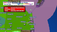
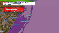
Thursday evening and Friday morning will see rainfall and potential flash flooding across Delmarva due to the remnants of Tropical Storm Debby merging with a stationary front.

AAA warns that Tropical Strom Debby could cause flooding on Delaware roadways
News

AAA warns that Tropical Strom Debby could cause flooding on Delaware roadways

  • Faith Givens
  • Aug 8, 2024

As Tropical Storm Debby comes towards Delaware, AAA gives drivers safe driving tips during the extreme weather.

2:17+2
Sonar Technology Enhances Angling Experience at 51s White Marlin Open
News

Sonar Technology Enhances Angling Experience at 51s White Marlin Open

  • Kevin Zipay
  • Updated Aug 8, 2024

As the 51 annual White Marlin Open unfolds, anglers are not only casting their lines but also relying on cutting-edge sonar technology to track down the biggest catches.

+2
Heavy rain and humidity as Debby approaches
Weather

Heavy rain and humidity as Debby approaches

  • Chief Meteorologist Paul Williams
  • Aug 8, 2024

A stalled frontal boundary and tropical moisture from Tropical Storm Debby will bring heavy rain and high humidity to Delmarva on Thursday and Friday.

+3
Cold Front Brings Rain and Fog Tonight, Clearer Conditions by Morning
Weather

Cold Front Brings Rain and Fog Tonight, Clearer Conditions by Morning

  • Chief Meteorologist Paul Williams
  • Aug 7, 2024

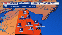
A slow-moving cold front will bring rain and potential fog tonight before stalling over the Mid-Atlantic. Expect clearer skies and drier conditions by tomorrow morning.

Maryland Governor signs State of Preparedness ahead of Hurricane Debby
News

Maryland Governor signs State of Preparedness ahead of Hurricane Debby

  • Madeleine Overturf
  • Aug 6, 2024

This order empowers the Department of Emergency Management to coordinate state government preparations, offering an additional layer of protection for Marylanders without declaring a State of Emergency.


site-logo
Facebook Instagram Threads X BlueSky YouTube LinkedIn

    Sections

    • Home
    • News
    • Weather
    • CoastLife
    • Delmarva Sports Network
    • Telemundo Delmarva

    Services

    • Contact Us
    • Submit a tip
    • Search
    • CoastTV Poll
    • Newsletter
    • Careers
    • Internships

    Browser Compatibility

    Your browser is out of date and potentially vulnerable to security risks.
    We recommend switching to one of the following browsers:

    Microsoft Edge Google Chrome Firefox
    © Copyright 2025 CoastTV One The Sq, Milton, DE  | Terms of Use  | Privacy Policy
    Powered by BLOX Content Management System from BLOX Digital.