


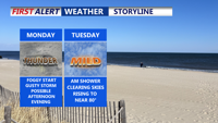
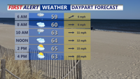
Sussex County can expect scattered showers Friday evening and again Saturday afternoon, with breezy conditions and temperatures remaining slightly below normal.
From
To

Sussex County will experience cooler-than-average temperatures and intermittent showers from early Friday through early Sunday, with improving conditions by Sunday afternoon.

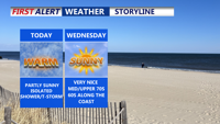
Patchy fog gives way to partly sunny skies and warm temperatures. A mix of isolated showers and storms will punctuate the rest of the week as multiple upper-level systems move through the region, bringing cooler temperatures and increased rain chances into the weekend.


A slow-moving upper-level low will bring continued showers, fog, and a chance of thunderstorms to Delaware's coastal areas through early Wednesday, followed by a midweek lull before more unsettled weather returns.

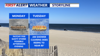
A slow-moving weather system will bring showers and a slight risk of severe storms to Delmarva early in the week, with milder and partly sunny conditions expected by midweek. A cold front arrives late Wednesday into Thursday, ushering in cooler air and the chance of spotty showers. Temperatures will rebound slightly over the weekend as high pressure returns.

A slow-moving upper-level system will bring rounds of showers and potential storms to Delmarva through midweek, followed by improving weather and cooler temperatures heading into the weekend. Monday and Tuesday will remain mild with highs in the 70s, but a late week cold front could trigger thunderstorms with damaging winds and hail before high pressure settles in by the weekend.


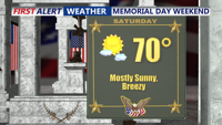
Warm, breezy conditions Saturday will give way to increasing shower and storm chances late this weekend across Delmarva. While severe weather remains unlikely, heavy rain and thunderstorms could impact the area Sunday and early next week as a slow-moving front lingers.

Blustery winds and cooler-than-normal temperatures will dominate Tuesday and Wednesday, with scattered showers and a risk of small hail in parts of the region.


A cold front will spark evening storms with hail and wind possible, followed by a breezy and much cooler Tuesday through midweek.

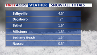
Some of Delmarva woke up Thursday to a blanket of powdery snow, while others saw nothing at all. A sharp precipitation cutoff left areas north of Georgetown mostly dry, while southern Sussex County recorded 1 to 4 inches, and Chincoteague measured 6.5 inches. Bitter cold and gusty winds dominate the forecast, with wind chills dropping into the single digits overnight. A Winter Weather Advisory remains in effect for parts of the Lower Shore until 6 p.m. Friday will bring sunshine but remain brisk before a milder, calmer weekend.