


DELMARVA - From a calm Monday afternoon to an active weather late tonight as a cold front pushes through the region. This front, tied to a low-pressure system over southern Ontario, will bring widespread showers between 10 p.m. and 2 a.m., with the potential for embedded thunderstorms, especially across southern Delaware and the Eastern Shore of Maryland.
The primary threat from these storms will be damaging wind gusts and small hail, particularly in areas south of the I-78 corridor where elevated instability remains. The Storm Prediction Center has placed this area under a marginal risk for severe weather Monday evening due to 40 to 50 knot wind shear in the mid-levels of the atmosphere.
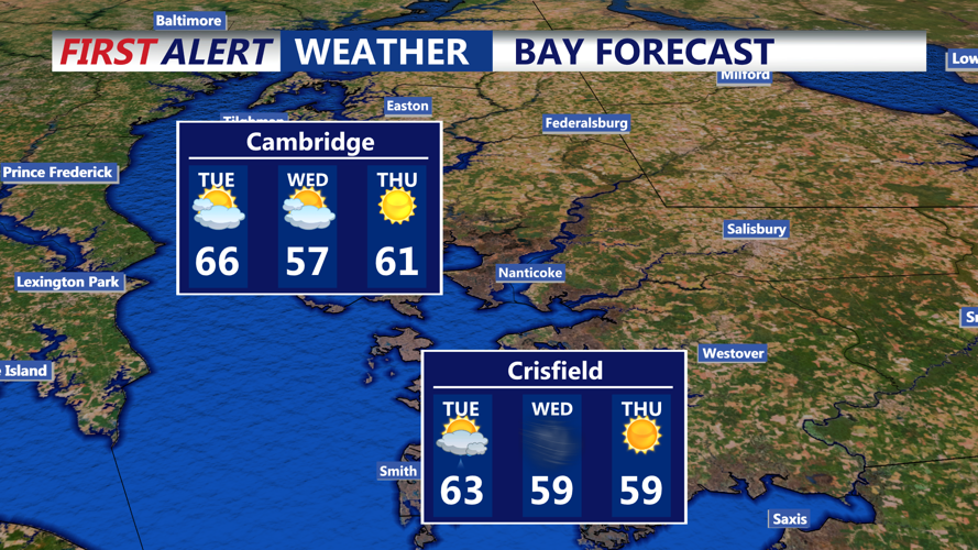
By Tuesday, the region will be under the influence of an upper-level low. While much of the day will remain dry, scattered coastal showers are possible in the morning with additional convective showers in the Poconos during the afternoon. Any afternoon showers may contain small hail or graupel due to steep lapse rates and low freezing levels. Temperatures will top out in the upper 50s to mid-60s with strong northwest winds gusting up to 40 mph.
A secondary cold front will pass through Tuesday night, likely without precipitation, but reinforcing cooler air. Overnight lows will drop into the upper 30s and low 40s with breezy conditions continuing into Wednesday.
Wednesday will be dry and seasonably cool, with highs in the 40s and 50s under a mix of sun and clouds. Winds will remain gusty, ranging from 25 to 35 mph, before tapering off Wednesday night. Clear skies and lighter winds will allow for colder temperatures overnight, with lows in the mid-30s and some areas dipping near freezing—potentially the coldest night of the week.
The latter part of the week brings a return to more tranquil conditions. Thursday and Friday will feature sunshine and gradually warming temperatures, reaching into the 60s by Friday. Another system is expected to approach by Friday night into Saturday, bringing another chance for showers and milder temperatures before a cold front brings cooler air by Sunday.