


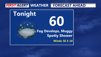
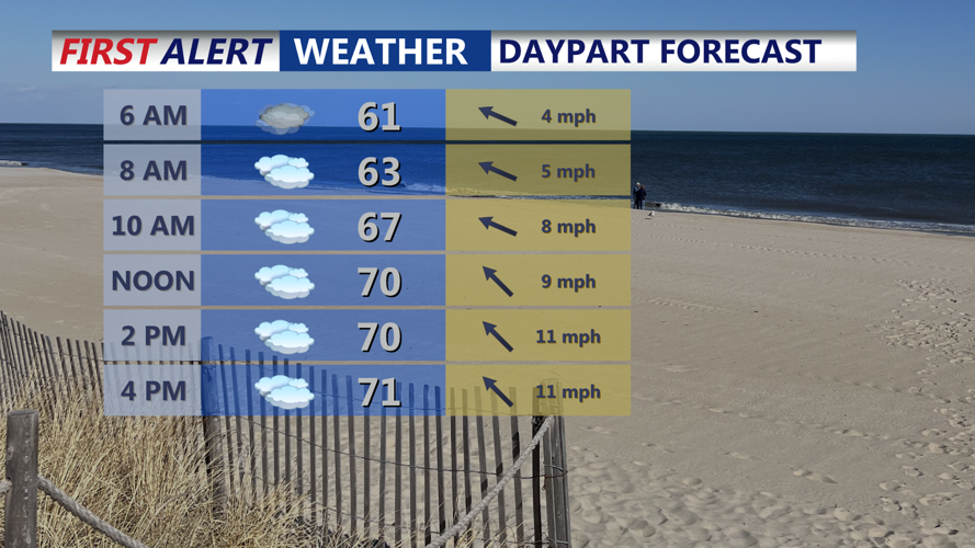


DELMARVA -- An upper-level low centered over the Ohio Valley Sunday night will inch eastward through early week, keeping Delmarva under unsettled skies and periods of showers. Overnight temperatures will remain mild, generally in the low to mid 60s, with patchy fog possible in some areas.

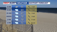
Fog develops Sunday night, spotty shower, muggy and damp.
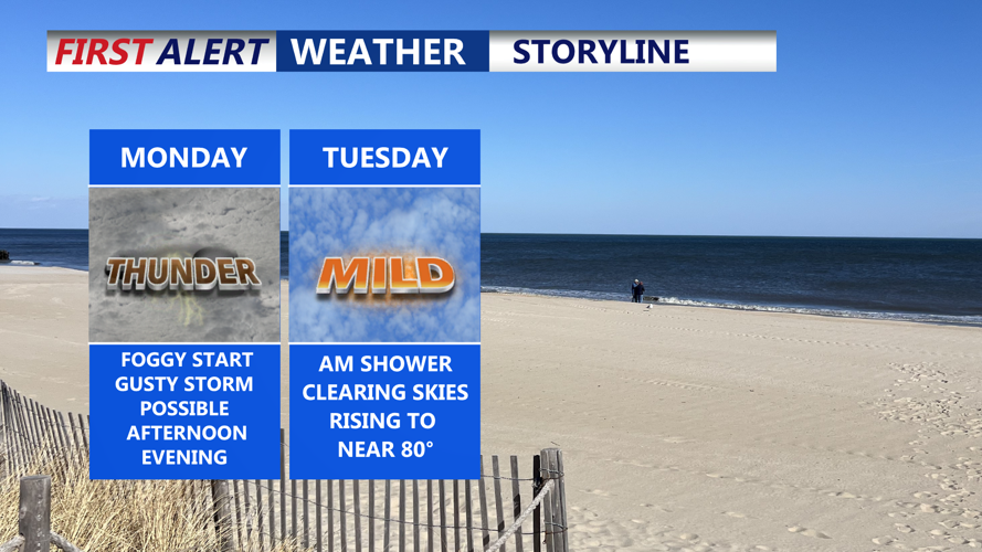
On Monday, expect mostly cloudy skies and scattered showers across the region. A strong high-pressure system building south from Quebec into the Canadian Maritimes will interact with the low to our west, enhancing atmospheric instability.

Cloudy skies Monday, temperatures in the low 70s, afternoon/evening shower, gusty storm.
The Storm Prediction Center has placed Delmarva under a Marginal Risk for severe weather, with damaging winds and large hail as the primary threats. The severe risk is low, the best chance is across the Eastern Shore. Highs will reach the low to mid 70s inland, with cooler 60s near the coast.

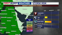
Storm Prediction Center has a "marginal" risk for western half of Delmarva, an isolated gust storm is possible with hail.
By Monday night, a stronger shortwave disturbance will swing through, bringing a renewed chance of thunderstorms and locally heavy rainfall. While some drying may occur across southern Delmarva overnight, clouds and light southeasterly winds will persist.
Tuesday should bring a break from the wet weather for much of the region, especially during the afternoon. An isolated shower or storm is still possible, primarily to the north. Highs will climb into the upper 70s to near 80 degrees under partly sunny skies.
Wednesday looks to be the best weather day of the week across Delmarva, with mostly sunny skies and highs in the mid to upper 70s. However, changes return quickly as a cold front approaches the area by early Thursday morning.
That front will sweep through with limited forcing, though a few showers may accompany it depending on available moisture and instability. Temperatures Thursday will range from the 60s to low 70s, with cooler readings closer to the coast.
As we move into Friday, a reinforcing upper-level trough will dig into the Northeast and Mid-Atlantic, bringing a cooler air mass and possibly a few instability-driven showers. Rain chances are possible, otherwise clouds and breezy conditions may be more noticeable.
Looking ahead to the weekend, high pressure is expected to build in, bringing dry weather and moderating temperatures. Saturday and Mother's Day should feature partly to mostly sunny skies with highs gradually rebounding from Friday’s dip, making for a pleasant end to the week across Delmarva.
